Coto de Caza

City Market · City Intelligence Published · Orange County, California

Coto de Caza is one gated identity holding several different housing markets. Early Village custom homes, first generation production tracts, later executive production, attached product, hillside custom homes and multi acre equestrian estates all sit behind the same gates. The tract and housing generation tell you what to compare first. Usable land, topography, golf and open space relationship, gate position, association structure and effective age tell you what the property actually is.

Technical designation: Coto de Caza is an unincorporated community in Orange County. It is treated as a city-level market within this platform because that reflects common South Orange County real estate usage and market-search behavior.

An eight-module guided path through the Coto de Caza research, for agents learning the market rather than looking something up.

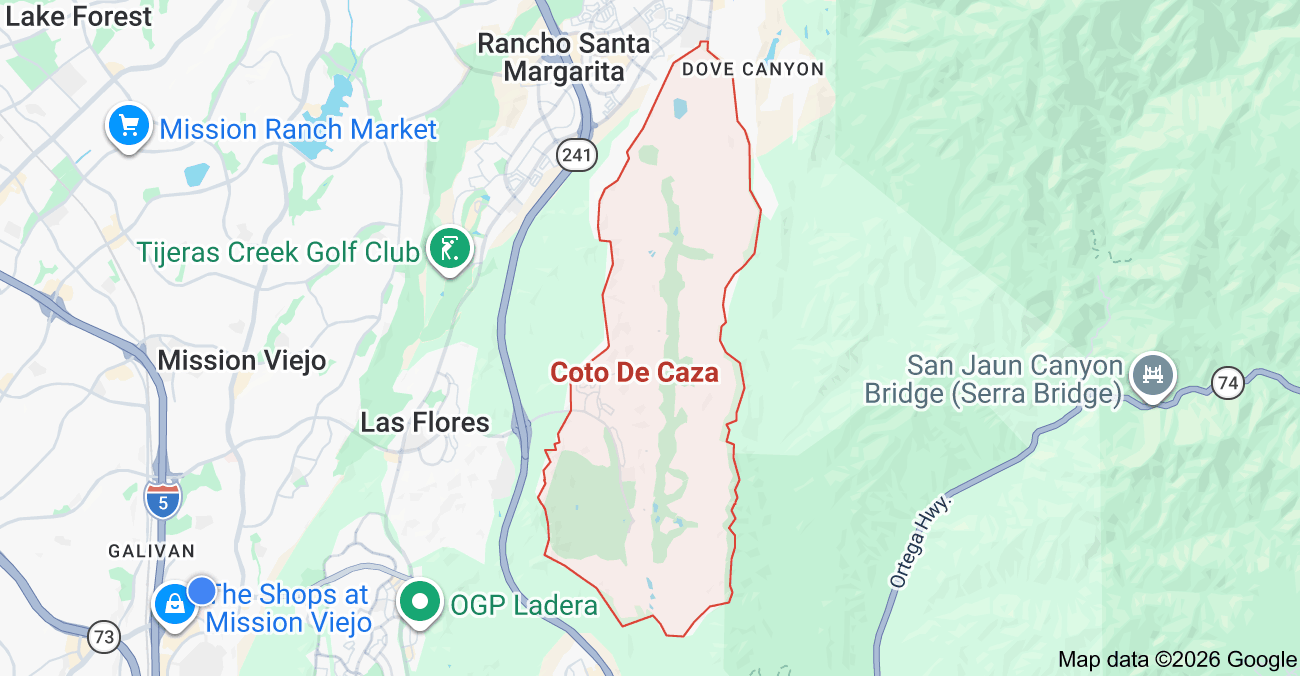
Orientation map showing Coto de Caza within South Orange County, California
Coto de Caza orientation map. For geographic orientation only. Do not rely on this image as an official municipal, market, subdivision, parcel or association boundary.

Open in Visual AtlasCompare This MarketClient Prep

Durable research last reviewed September 4, 2026

Market Brief

Coto de Caza in Brief

Market Identity

Coto de Caza is a large guard gated foothill market made up of multiple housing generations, production subdivisions, attached housing pockets, custom enclaves, golf oriented neighborhoods and equestrian estate product. It reads more reliably by tract, housing generation, usable lot, topography, golf and view relationship, access, association structure and effective age than by a citywide price per square foot.

Housing Snapshot

The durable housing ladder runs from attached villas and condominiums, through early Village custom and semi custom housing, first wave master planned production, later South Coto move up production, large executive production estates, custom hillside housing and multi acre equestrian estate product, into later custom infill and rebuilds.

Common Alternatives

  • Dove Canyon
  • Nellie Gail Ranch
  • Ladera Ranch
  • Rancho Mission Viejo
  • San Juan Capistrano estate product
  • Selected Mission Viejo luxury product

Key Value Drivers

  • Named tract and housing system
  • Usable land and site utility
  • Golf, view, open space and backing relationship
  • Three gate access context
  • Custom versus production product
  • Effective age and documented major system upgrades
  • Privacy, elevation and street position

Important Watchouts

  • Association layering and private club assumptions
  • Tax and assessment assumptions
  • Horse right assumptions
  • Slope, drainage and retaining wall responsibility
  • Fire and insurance diligence
  • School assignment
  • Builder and floor plan claims that are still research scaffold

Structured intelligence last reviewed September 4, 2026. HOA dues, sub association obligations, private club membership, taxes, special assessments, school assignment, fire hazard severity zone, insurance, horse keeping rights, permits, legal square footage, slope responsibility, builder and floor plan details, and current market statistics must be verified for the specific property.

Quick Intelligence

Coto de Caza Market Intelligence

A structured summary of the durable research below. The lens narrows this summary only. The full research sections on this page are always available.

Value Drivers

Coto is several housing markets behind one set of gates

Coto contains older custom housing, first generation production, later executive production, attached product, hillside custom estates and equestrian properties. Before you use a comp, identify which housing system the subject actually belongs to.

  • Older custom and Village era housing
  • First and later generation production tracts
  • Attached and lower maintenance product
  • Hillside custom and acreage estate product
Go deeper

Usable land can matter more than headline acreage

A large Coto parcel can include slope, drainage courses, easements, fuel modification areas or terrain that never functions as yard. Compare what the buyer can actually use, not just the recorded lot size.

  • Flat rear yard and pool area
  • Slope gradient and retaining systems
  • Easements and maintenance responsibility
Go deeper

Tradeoffs

Coto has three primary access gates

County planning and traffic documents identify three primary entrances, commonly described as North, West and South gates. Where a property sits inside the community can materially change how convenient the home feels day to day.

  • Route the client's real weekly destinations
  • Test travel at the times that actually matter
  • Do not quote fixed drive time savings as permanent facts
Go deeper

Golf frontage is not one location type

Buyer

Course level frontage, elevated golf views, green adjacency, tee proximity, cart path exposure and more distant golf views create different privacy, noise, view and ball exposure experiences.

Go deeper

Watchouts

Homeownership and private club membership are separate systems

Coto de Caza Golf and Racquet Club is a private membership club with its own membership categories and pricing. Do not assume that owning a home automatically provides the golf, racquet, fitness or social privileges a buyer expects.

Go deeper

Equestrian setting does not establish horse rights

Buyer

Coto has a real equestrian history, a trail system and an equestrian preserve. That does not mean every residential parcel permits on property horse keeping. Verify the parcel and the governing documents.

Go deeper

Competitive Set

The nearest sale may belong to the wrong housing system

Seller

A similarly sized custom Village home, a newer production home and a golf oriented tract home can appeal to different buyer pools even when they sit close together.

Go deeper

Seller Positioning

Effective age can matter more than original year built

Seller

A home with documented updates to major systems, layout, roof components, windows, plumbing, HVAC, pool and drainage competes differently from an original condition home of the same vintage.

Go deeper

Agent Talking Points

Planning Area, recorded tract and MLS subdivision are different layers

Agent Study

The County Specific Plan uses Planning Areas. Recorded maps use legal tract numbers. The market uses recognizable neighborhood and subdivision names. Keep all three layers rather than forcing them into one hierarchy.

Go deeper

Key Questions

  1. 01

    Which named tract or housing system is this property actually part of?

    Start with the recognizable market identity, then confirm the legal tract, Planning Area, builder, product type and association structure where relevant.

    Go deeper
  2. 02

    Which of Coto's three gates best serves this property and the client's routine?

    Do not rely on weekend touring impressions. Test actual routing to the destinations the client visits every week.

    Go deeper
  3. 03

    How much of the recorded lot is functionally usable?

    Evaluate flat pad, yard, pool area, slope, drainage, easements, access and maintenance obligations before you value the acreage.

    Go deeper
  4. 04

    What is the property's actual golf, view, wilderness or backing relationship?

    Classify the backing instead of using a generic golf or view label.

    Go deeper
  5. 05

    Which association layers apply to this parcel?

    Confirm master association, independent association, sub association, secondary gate, maintenance responsibilities and current assessments.

    Go deeper
  6. 06

    Does the parcel have verified equestrian rights, or simply equestrian proximity?

    Trails, nearby stables and community identity do not establish legal on site horse use.

    Go deeper
  7. 07

    What special taxes or public assessments appear on the current tax bill?

    Do not infer current charges from neighborhood age or from a generic no Mello-Roos claim.

    Go deeper
  8. 08

    What does the current fire hazard map show for this address, and can the buyer insure it?

    Fire classification and property specific insurability are two different questions.

    Go deeper
  9. 09

    What housing generation, builder and floor plan define the competitive set?

    Use the market structure first, then widen the comp radius.

    Go deeper

Coto de Caza at a Glance

Unincorporated Orange County
Coto is a Census Designated Place, not an incorporated city. Orange County remains the land use, subdivision and permitting authority.
14,710 residents, 7.80 square miles
The 2020 Census figures for the Coto de Caza CDP. Census boundaries are not the same as the Specific Plan area, the gated boundary, HOA boundaries or the 92679 mailing area.
First homes in 1975
County historical records place the first homes in The Village, built by Great Southwest Corporation along Via Alondra.
Three primary gates
County planning and traffic documents identify North, West and South entrances. This is not a two gate community.
36 holes of private golf
Coto de Caza Golf and Racquet Club runs two Robert Trent Jones Jr. courses, the North Course from 1987 and the South Course from 1995.
Roughly 5,000 homes built
Recent County planning documents place constructed residential inventory near 5,000 units against a Specific Plan maximum of 6,268. County figures differ slightly by reporting date and document.

The Geography Explains the Market

A foothill valley, not a flat tract grid

Setting

Coto sits in a foothill valley with canyon edges, ridges, terraced pads and long internal roads. Topography drives view, privacy, yard usability and construction complexity.

Coto de Caza Drive is the spine

Roads

Coto de Caza Drive, Vista del Verde, Via Pajaro and South Bend Road organize the community internally, with Plano Trabuco Road, Antonio Parkway and Oso Parkway carrying regional access.

The club core sits in the middle

Core

Two golf courses, the clubhouse and the equestrian preserve occupy the center of the valley, which is why golf, view and open space relationships repeat across many tracts.

Wilderness on both sides

Open space

OC Parks places Thomas F. Riley Wilderness Park, 540 acres, along the western and southwestern edge near Oso Parkway and Coto de Caza Drive. Caspers Wilderness Park, roughly 8,000 acres, sits east and southeast.

Limited retail inside the gates

Lifestyle

Daily errands generally happen outside the gated residential environment. Privacy and separation can mean more driving.

92679 is bigger than Coto

Caution

The ZIP covers multiple unincorporated housing systems. A ZIP only CMA or AVM will blend properties that are not reasonable substitutes.

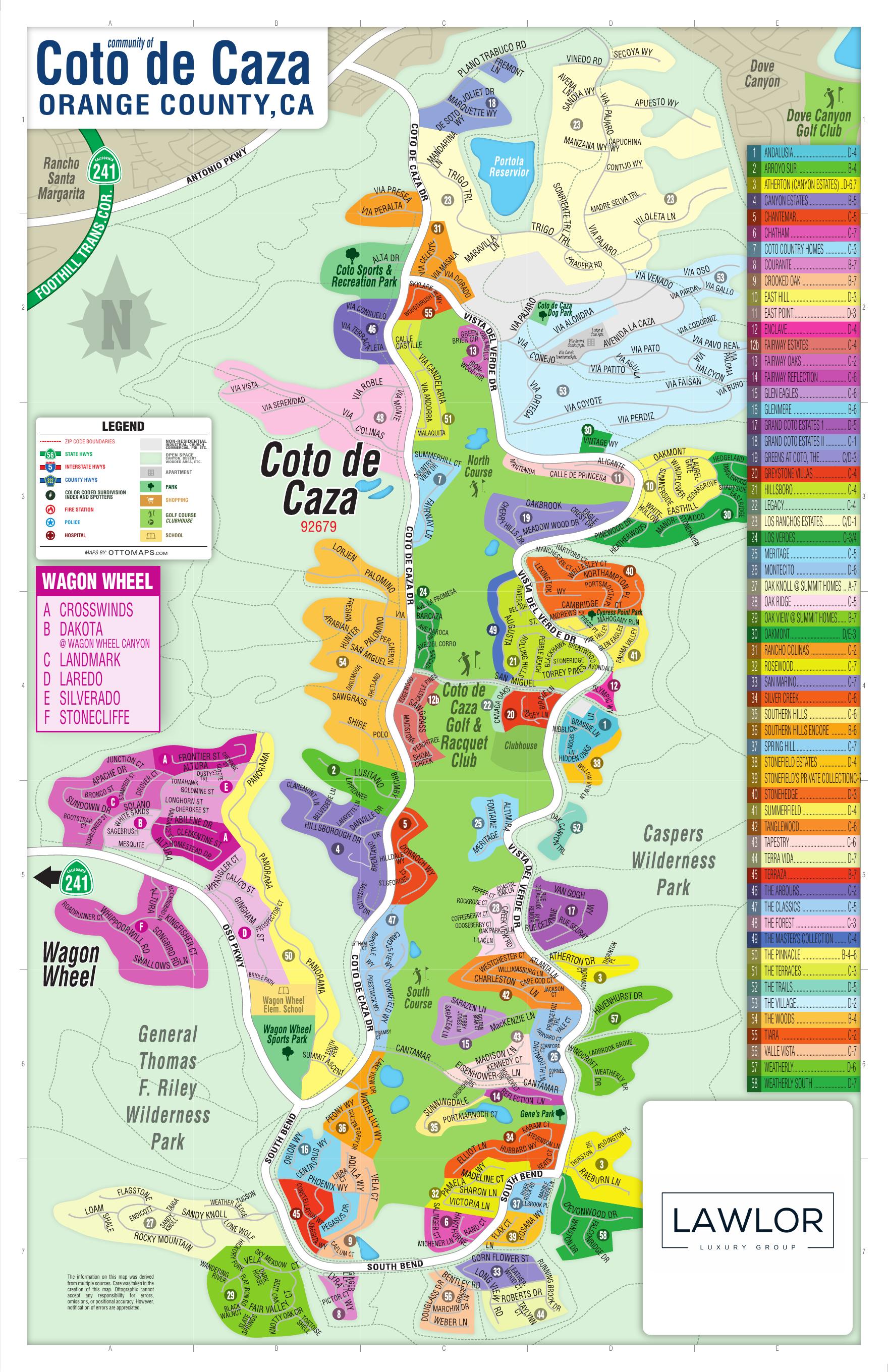
Coto de Caza Subdivision Map

Subdivision map of Coto de Caza showing numbered neighborhood areas across the valley

Pinch, scroll or use the controls to zoom. Drag to pan.

Orientation map indexing 58 numbered areas plus Fairway Estates as 12b.

Use this map for orientation only. It indexes 58 numbered entries plus Fairway Estates as 12b. Inclusion preserves a market name. It does not prove the recorded tract, builder, unit count, association structure, construction years or floor plans for any of those areas.

How to Read the Coto Market

  1. 01

    Start with the tract

    Identify the recognizable market name first. It tells you the general product and where to begin the comp search.

  2. 02

    Place the housing generation

    Early custom, first production wave, later executive production or custom infill. Each one carries different comp logic.

  3. 03

    Read the site

    Usable pad, slope, drainage, easements, elevation and street position, not just the recorded acreage.

  4. 04

    Classify the backing

    Interior neighbor, golf, canyon, open space, road, slope or trail. Then classify the view separately.

  5. 05

    Verify the layered systems

    Association structure, club expectations, tax bill, fire designation, insurance, school assignment and horse rights all sit at parcel level.

Three Gate Geography

Three primary entrances

The correction

County planning and traffic documents identify three primary entrances, commonly described as North Gate, West Gate and South Gate. County documents have used different intersection descriptions depending on the study, so the durable fact is the three gate system rather than one universal naming diagram.

Why it matters

Why

Coto is large and internally long. The practical gate for a property, and the internal route to reach it, can change how the same commute feels from two tracts that look similar on paper.

How to use it with a buyer

Application

Identify the practical gate, route the client's real recurring destinations, test travel at the times that matter, then compare against competing Coto tracts.

What not to publish

Discipline

Do not claim that a tract saves twenty minutes a day, that North Gate is always best for Irvine, or that South Bend is always less convenient. Those are route and client specific observations.

The Canonical Hierarchy

Level 1

Coto de Caza sits at City level

One City Market under South Orange County. Everything else sits beneath it.

Level 2

The Village and Los Ranchos Estates are communities

Both earn community level treatment. The Village has a distinct historical origin, governance identity and housing product. Los Ranchos Estates is an estate and equestrian system with separate association identity and site specific valuation.

  • The Village, the 1975 origin of Coto
  • Los Ranchos Estates, acreage and equestrian estate product

Level 3

Most map names sit directly under Coto

The remaining map indexed names are carried as tract or subdivision records directly under Coto until recorded map research proves a more useful parent relationship.

Rule

Three layers, not one tree

The Specific Plan uses Planning Areas. Recorded maps use legal tract numbers. The market uses recognizable names. Keep all three rather than collapsing them.

  • Planning Area is regulatory metadata
  • Recorded tract is the legal identity
  • Market name is what buyers and agents actually use

Sectors

Geographic sectors are tags, not parents

North Coto, club core, South Course, South Bend and Summit, historic Village and Los Ranchos remain useful shorthand. They are stored as metadata rather than mandatory parent pages.

The Coto de Caza Specific Plan

6,268 dwelling units maximum

Entitlement

The Specific Plan maximum residential entitlement recognized in recent County planning documents.

225,000 square feet of commercial

Entitlement

The commercial maximum under the same framework.

2,290 acres of open space minimum

Entitlement

The minimum open space requirement in the Specific Plan framework.

Roughly 5,000 units built

Buildout

A 2023 County memo reported 5,027 constructed residential units and 2,317 acres of open space. A 2022 County environmental document reported 5,030 units and 2,345 acres. The small differences between County documents have not been fully reconciled.

Planning Areas are technical metadata

Planning Areas

Planning Areas govern land use designation, density, development standards, entitlement history and project review. They are not how buyers recognize neighborhoods and they do not become public market pages here.

Development History

  1. 1960s

    Hunting, equestrian and recreation origins

    Coto grew out of a private hunting, equestrian and recreation concept rather than a conventional suburban subdivision.

  2. 1970

    Coto Valley Country Club era

    County historical documentation traces the country club and recreation era to 1970, with expanding recreation and tennis activity.

  3. 1974

    Vic Braden Tennis College

    County historical resources documentation places the Vic Braden tennis college operation in the mid 1970s recreation era.

  4. 1975

    First homes in The Village

    County historical resources documentation states the first homes were built in 1975 by Great Southwest Corporation within The Village along Via Alondra. This corrects earlier research that framed residential construction as starting in 1970.

  5. 1979 to 1980

    The Arvida era begins

    County historical documentation states ownership transferred to Florida based Arvida in 1979, and contemporary reporting describes Arvida inheriting the project around 1980. Either way, Arvida's involvement began years before the 1985 to 1986 timing in earlier research.

  6. 1984

    Disney, Arvida and the Olympics

    The Walt Disney Company acquired Arvida in 1984, and historical sources describe a joint development structure. Coto also hosted the modern pentathlon during the 1984 Los Angeles Olympics, which is why the equestrian and recreation identity predates much of the housing.

  7. 1987

    North Course opens

    The Robert Trent Jones Jr. North Course opened in 1987.

  8. 1995

    South Course opens

    The Robert Trent Jones Jr. South Course opened in April 1995.

  9. 1996

    Lennar takes the remaining development

    Contemporary reporting states Lennar purchased roughly 2,200 acres and became manager of the remaining master planned development, with about 1,700 vacant housing lots left at that point.

  10. Late 1990s to 2003

    The late buildout wave

    The late 1990s into the early 2000s produced most of the branded neighborhoods shown on the current map. County documentation states Lennar's work on roughly 45 branded neighborhoods was complete by 2003.

  11. 2000s to now

    Custom infill and rebuilds

    Later activity is property specific: custom rebuilds, major renovations, individual infill and discrete entitlement projects.

Map Indexed Subdivision Library

The printed map index is preserved exactly, including Fairway Estates as entry 12b. Map inclusion means the name stays in the research library. It does not mean the legal tract, builder, unit count, association or floor plan is already solved.

MapNameGridTreatment
1AndalusiaD-4Tract or subdivision, map supported
2Arroyo SurB-4Tract or custom enclave candidate
3Atherton (Canyon Estates)D-6,7Tract or product, Canyon Estates relationship unresolved
4Canyon EstatesB-5Area or subdivision candidate, relationship to Atherton unresolved
5ChantemarC-5Tract or subdivision, map supported
6ChathamC-7Tract or subdivision, map supported
7Coto Country HomesC-3Tract or subdivision, map supported
8CouranteB-7Tract or subdivision, map supported
9Crooked OakB-7Tract or subdivision, map supported
10East HillD-3Tract or subdivision, map supported
11East PointD-3Tract or subdivision, map supported
12EnclaveD-4Enclave or tract candidate
12bFairway EstatesC-4Tract or subdivision, map supported
13Fairway OaksC-2Attached or condominium product candidate
14Fairway ReflectionC-6Tract or subdivision, spelling and plural alias check needed
15Glen EaglesC-6Tract or subdivision, alias Gleneagles should be checked
16GlenmereB-6Tract or subdivision, high research priority
17Grand Coto Estates 1D-5Tract or phase, alias Grand Coto Estates I
18Grand Coto Estates IIC-1Tract or phase, map supported
19Greens at Coto, TheC/D-3Tract or subdivision, map supported
20Greystone VillasC-4Attached product or subdivision candidate
21HillsboroC-4Tract or subdivision, map supported
22LegacyC-4Existing map area identity, separate from the archived Legacy at Coto proposal
23Los Ranchos EstatesC/D-1Community, verified distinct market system
24Los VerdesC-3/4Attached or townhome product candidate
25MeritageC-5Tract or subdivision, map supported
26MontecitoD-6Tract or subdivision, builder attribution conflict
27Oak Knoll at Summit HomesA-7Tract or gated pod candidate, high research priority
28Oak RidgeC-5Tract or subdivision, map supported
29Oak View at Summit HomesB-7Tract or gated pod candidate, high research priority
30OakmontD/E-3Tract or subdivision, map supported
31Rancho ColinasC-2Tract or subdivision, map supported
32RosewoodC-7Tract or subdivision, map supported
33San MarinoC-7Tract or subdivision, map supported
34Silver CreekC-6Tract or subdivision, map supported
35Southern HillsC-6Tract or subdivision, map supported
36Southern Hills EncoreB-6Tract or phase, seen independently in current MLS naming
37Spring HillC-7Tract or subdivision, map supported
38Stonefield EstatesD-4Tract or subdivision, map supported
39Stonefield's Private CollectionC-7Product or phase candidate, relationship needs verification
40StonehedgeD-3Tract or subdivision, map supported
41SummerfieldD-4Tract or subdivision, map supported
42TanglewoodC-6Tract or subdivision, map supported
43TapestryC-6Tract or subdivision, map supported
44Terra VidaD-7Tract or subdivision, map supported
45TerrazaB-7Tract or subdivision, map supported
46The ArboursC-2Tract or subdivision, map supported
47The ClassicsC-5Tract or subdivision, map supported
48The ForestC-3Custom area or subdivision candidate
49The Master's CollectionC-4Custom or golf oriented collection candidate
50The PinnacleB-4-6Tract or subdivision, high research priority
51The TerracesC-3Tract or subdivision, high research priority
52The TrailsD-5Tract or subdivision, map supported
53The VillageD-2Community, verified historic market system
54The WoodsB-4Custom area or subdivision candidate
55TiaraC-2Tract or enclave candidate
56Valle VistaC-7Tract or subdivision, map supported
57WeatherlyD-6Tract or subdivision, high research priority
58Weatherly SouthD-7Phase or subdivision candidate, relationship to Weatherly unverified

Names That Still Need Reconciling

Atherton and Canyon Estates

Unresolved

The map lists Atherton (Canyon Estates) and Canyon Estates separately. That could be a parent and child relationship, a marketing phase, an alias, adjacent products or overlapping branding across different recorded tracts. Do not collapse them until recorded map and builder evidence is reviewed.

Grand Coto Estates 1 and II

Phases

Keep the phases separate and carry both alias spellings, Grand Coto Estates 1 and Grand Coto Estates I.

The Stonefield system

Unresolved

Stonefield Estates, Stonefield's Private Collection and San Marino need reconciling before any parent and child relationship is assigned.

Southern Hills and Encore

Phases

Keep separate records until the phase and tract map relationship is documented.

Weatherly and Weatherly South

Phases

Keep separate map records. Do not assume Weatherly South is only an informal sub area.

Two different Legacys

Name collision

Legacy is an existing mapped neighborhood. Legacy at Coto was a proposed senior housing redevelopment of the former Vic Braden Tennis College site. They are different records and should never be merged.

Development Watch

Proposed

Oak Grove

County materials describe a proposal involving roughly 5.1 acres and 13 single family homes, with Specific Plan amendment and tract map processing. Treat it as a proposal, not an existing Coto tract.

Entitlement history

VTTM 17950, the Lyon property

County approval documentation verifies a proposal and approval history in Planning Area 7 covering roughly 63.9 acres and 25 residential lots at a two acre minimum lot size, with private infrastructure and open space conditions. Recordation and current construction status still require verification.

Archived

Legacy at Coto

The senior housing proposal for the former Vic Braden Tennis College site appears in County archived project material. Treat it as an archived proposal unless a current County application is identified.

Four Housing Generations

These generations are market analysis taxonomy, not County classifications. Use them to teach the market, not to imply that every home built in a date band shares the same construction characteristics.

  1. Mid 1970s into the 1980s

    Early Coto, Village and custom origins

    Custom and semi custom housing, irregular sites, mature landscape, unconventional floor plans, older systems and more variation in permit history. Comp logic here looks nothing like production housing.

  2. Later 1980s into early 1990s

    First master planned production

    Production housing with formal room layouts, earlier golf oriented neighborhoods, established landscaping and conventional lot patterns. Unrenovated homes carry aging original mechanical and finish packages.

  3. Mid 1990s into early 2000s

    Southward production and executive buildout

    Larger production homes, more open kitchen and family room relationships, larger garages, more downstairs bedroom options and executive estate product, along with South Course and South Bend development.

  4. Mid 2000s to present

    Custom infill, rebuilds and redevelopment

    Custom rebuilds, major renovations, individual infill, entitlement specific projects and contemporary architecture. Comp selection becomes highly property specific.

The Housing Product Ladder

Coto is not a detached only luxury market. The reputation is narrower than the actual housing stock.

Attached and lower maintenance

Attached

Map and research candidates include Fairway Oaks, Los Verdes, Greystone Villas and Andalusia, along with other attached pockets that still need tract level verification.

Smaller detached Coto

Entry detached

Some production tracts provide a smaller detached entry point relative to the larger executive estates. The Terraces is a high priority example for floor plan verification.

Move up production

Move up

Numerous late 1980s through late 1990s tracts fall into conventional move up detached housing.

Executive production

Executive

Larger later generation production homes can overlap custom home size while still keeping builder plan comparability.

Custom hillside

Custom

The Woods, The Forest and Arroyo Sur are map and research candidates for custom enclaves that still need recorded map verification.

Equestrian and acreage estate

Estate

Los Ranchos Estates is the clearest community level market for this product.

Attached Housing Intelligence

Do not apply detached home pricing logic to attached product just because both sit behind the Coto gates.

  • Legal ownership type

    Condominium, planned development or another structure entirely.

  • Exterior and roof responsibility

    Who repairs and who reserves for it.

  • Master and sub association

    Both layers, with current dues and assessments dated.

  • Insurance responsibility

    Association policy scope against owner responsibility.

  • Garage, parking and common walls

    Assigned parking, guest parking and wall conditions.

  • Outdoor space rights

    Exclusive use areas against common area.

  • Golf and club relationship

    What the property includes and what requires membership.

  • Reserves and assessments

    Current reserve position and any pending special assessment.

Construction and Property Diligence

These are questions worth asking, not tract wide defect labels. Earlier research made broad claims about copper corrosion and repiping across Coto. There is no Coto specific authoritative dataset supporting that, so the topic stays a property diligence question: for homes from relevant construction eras, ask whether the plumbing has been repiped and review disclosures, permits, repair history and inspection findings. The useful principle is effective age, not a fixed defect list or a fixed price adjustment.

Early custom and Village era

Older custom homes carry the widest variation in permit and improvement history.

  • Permit history and additions
  • Roof, windows and electrical
  • Plumbing and historic utility conditions
  • Drainage and foundation
  • Decks and outdoor structures
  • Wildfire hardening
  • Mature tree constraints

First generation production

Original mechanical and finish packages are the main question in unrenovated homes.

  • Plumbing
  • Roof underlayment and roof system age
  • HVAC
  • Windows
  • Interior layout modernization
  • Drainage
  • Pool condition

Later executive production

Bigger homes carry more systems and more site improvements.

  • Plumbing
  • Multiple HVAC systems
  • Pool and hardscape
  • Retaining walls
  • Slope drainage
  • Engineered fill
  • Original finish packages
  • Renovation quality

Custom hillside and estate

Site engineering becomes as important as the house.

  • Grading and geotechnical reports
  • Retaining walls and drainage
  • Foundation
  • Accessory structures and permits
  • Landscape and fuel modification
  • Driveway and private access
  • Legal animal facilities where relevant

Usable Land Versus Recorded Acreage

The concept

What a large parcel can hide

Recorded acreage can include steep slope, drainage courses, easements, fuel modification areas, retaining systems, undeveloped canyon and landscape maintenance obligations. A smaller flatter lot can deliver more functional outdoor utility than a much larger hillside parcel.

Field work

What to evaluate

Walk the property with a list rather than a lot size.

  • Flat rear yard and side yard usability
  • Pool area and driveway
  • Play and recreation space
  • Slope gradient and retaining walls
  • Access to lower and upper terraces
  • Easements
  • Maintenance responsibility

Positioning

Seller rule

Do not lead with acreage when the buyer experience is dominated by the usable pad. Position the yard accurately and the acreage honestly.

Uphill, Downhill and Terrace Sites

Uphill and ascending sites

Ascending

Driveway grade, retaining structures, terraced rear yard, elevation above street, steps and drainage arriving from upslope.

Downhill and descending sites

Descending

View potential, lower level construction, foundation and structural design, downslope drainage, pool and deck engineering, and yard separation from main living areas.

Terrace and engineered pad sites

Engineered

Retaining systems, subdrains, slope ownership, association against homeowner maintenance, and geotechnical history.

Slopes, drainage and retaining structures

Diligence

For hillside or terraced property, investigate slope ownership, recorded maintenance responsibility, common area against fee simple slope, retaining wall ownership, drainage paths, area drains, subdrains, erosion, prior repairs, geotechnical reports, grading plans and permits.

Both things can be true

Judgment

A canyon or slope can be a view and privacy asset while also carrying real maintenance obligations. No configuration is inherently superior.

View Intelligence

View classes

Classification

Golf course, valley or basin, mountain and Saddleback, canyon, open space and wilderness, sunset and directional, combination, and filtered or partial.

Where the view lives

Question

Ask whether the view is visible from primary living areas or only from upper floors, and whether it is panoramic or directional.

Foreground matters

Question

What sits between the house and the view usually determines how the view is experienced and whether it reduces privacy.

Durability

Question

Landscaping, wind exposure and slope or course maintenance can change the experience over time.

No generic premium

Rule

Do not assign a Coto view premium. Classify the view, then test the market response.

Golf Real Estate Micro Locations

The courses

Two courses, 36 holes

Coto de Caza Golf and Racquet Club operates 36 holes across two Robert Trent Jones Jr. courses. The North Course opened in 1987 and the South Course in April 1995.

Frontage

Course level frontage

Direct visual relationship, green space and depth beyond the rear property line, traded against golfer visibility, maintenance activity, cart and equipment noise, and ball exposure depending on hole position.

Elevated

Elevated golf view

Broader view, better privacy and less direct course interaction, traded against slope, wind, less usable yard and engineered site complexity.

Position

Tee, green and cart path adjacency

Tee adjacency has a different privacy and activity pattern from fairway landing areas. Green adjacency concentrates golfer dwell time. Cart path adjacency creates its own noise and privacy pattern.

Rule

Golf frontage is not one premium category

MLS and field research should test individual hole and orientation patterns rather than assign fixed percentages.

Equestrian Intelligence

Current facility

Coto Equestrian Preserve

The current facility reports 24.1 acres, roughly 150 boarded horses and six riding arenas, owned by Caprilli Equestrian and operated by Cinnabar Equestrian Operations. Coto Equestrian Center is the historical name and belongs in historical discussion only.

The distinction

Lifestyle access is not a legal right

Trails, a boarding facility, nearby riding and equestrian culture are lifestyle access. Legal on property horse keeping is a separate, parcel specific question.

Case study

The Village example

County meeting records include a Village representative stating that The Village does not have lots with equestrian use, while The Village maintains equestrian trails in Tract 6970 that support wider Coto trail connectivity. Trail access does not establish horse keeping rights on the parcel.

Verification

What to verify in Los Ranchos and elsewhere

Do not assume identical horse rights, a fixed permitted horse count, arena or barn rights, usable acreage or identical setbacks across parcels.

  • County zoning and entitlement
  • Recorded CC and Rs
  • Easements
  • Animal keeping standards
  • Permits
  • Lot configuration
  • Association review

Single Story Intelligence

Real demand, thin data

Status

Single story and main floor living opportunities exist in selected production tracts, but plan level distribution is still research scaffold here.

What has to be confirmed first

Verification

A true one story model, its prevalence in the tract, downstairs primary against downstairs guest room, plan modifications and any additions or conversions.

Why it matters

Market effect

Single story detached product attracts a different buyer pool than large two story executive homes, especially for buyers who still want gated living, a yard, a view and golf proximity.

Do not publish it early

Rule

No tract is described as single story here until the floor plan library supports it. Listing remarks are not a plan library.

Builder and Floor Plan Research Status

Builder and floor plan fields stay research scaffold until verified against builder brochures, recorded maps and County records, InsideTract, CRMLS historic subdivision and model data, permits and archived advertisements.

Where it stands

Verified at community level, not tract level

Historical sources verify major builder activity in Coto, including J.M. Peters, Douglas Gfeller, Lennar and other merchant builders during buildout. That is not the same as a verified builder attribution for each tract.

Conflict

A known conflict

Contemporary 1996 reporting referred to a Greystone Montecito project while the earlier research matrix attributed Montecito differently. One conflict of that kind is enough to require tract by tract verification.

Fields

What each tract needs

Original builder, recorded tract number, construction years, home count, plan count, square footage range, stories, downstairs bedroom and primary options, garage, original architecture and sub association.

Queue

Floor plan priorities

Weatherly, The Pinnacle, Glenmere, Oak Knoll at Summit, Oak View at Summit, Fairway Estates and The Terraces carry the highest research value. The Village is a priority for original tract research and remodel patterns rather than a builder plan library.

The Micro Location Framework

Single loaded street position is a reasonable market hypothesis, not a settled premium. Fewer facing homes, open streetscape and view exposure trade against slope or edge exposure, vegetation interface, road or trail adjacency and wind. Test it with MLS and field work before pricing it.

Gate and route

How the property actually connects to the outside world.

  • Practical gate
  • Internal travel
  • Arterial relationship

Street

Street type changes privacy, parking and traffic exposure.

  • Cul de sac or through street
  • Single loaded or double loaded
  • Parking
  • Traffic
  • Secondary gate

Backing and elevation

Two separate variables that are often collapsed into one.

  • Interior neighbor, golf, canyon, open space, road, slope or trail
  • Below street, level, above street or ridge
  • Neighboring roofline relationship

Lot, view and property

The rest of the analysis, in order.

  • Usable flat yard and slope
  • Pool, side yard and driveway
  • View class and orientation
  • Floor plan and story count
  • Condition, effective age and major systems

Wildfire and Insurance

Regulation

The current framework

Orange County adopted an updated Fire Hazard Severity Zone framework for unincorporated areas in August 2025. The current map uses Moderate, High and Very High classifications.

Rule

Verify by address

Check the specific property on the official current map. Do not publish or repeat that all of Coto is Very High, that Coto requires the FAIR Plan, that standard carriers will not insure Coto, or any generic Coto premium figure.

Workflow

Buyer workflow

Start early, because insurance is not a last week of escrow question.

  • Verify the current hazard classification
  • Get property specific insurance quotes early
  • Review roof, exterior and defensible space conditions
  • Understand association against owner fuel modification responsibility
  • Keep an appropriate insurance contingency where material

Distinction

Two different questions

Fire hazard classification is not the same as insurability or premium. A property can be classified one way and quoted very differently by two carriers.

OCFA

Station 40

OCFA lists Coto de Caza Station 40 at 25082 Vista del Verde. As of the September 2026 verification pass, OCFA lists daily staffing as one Fire Captain, one Fire Apparatus Engineer and one Firefighter, with PAU Engine 40 and Dozer 1 among the listed apparatus. Staffing is operational data and changes, so treat any figure as dated.

Governance and Associations

Do not flatten Coto into one generic HOA. The operating system is layered, and the layers do not apply identically to every parcel.

Public

Orange County

Planning, zoning, subdivision, grading, building permits and public safety functions sit with the County.

Advisory

CPAC

The Coto de Caza Planning Advisory Committee is an advisory land use body. County records show its geographic concern can include Wagon Wheel Canyon, which is another reason to keep regulatory context separate from the public market hierarchy.

Associations

Major private residential systems

County records and the source research distinguish CZ Master Association, the Coto de Caza Community Association and The Village, and Los Ranchos Estates HOA.

Layers

Additional private layers

A property may also involve a condominium association, a tract sub association, a secondary gate or pod association, a maintenance association or shared private infrastructure.

Club

The club is a separate business

Coto de Caza Golf and Racquet Club is a private club. It is not government and it is not a substitute for residential association analysis.

Association Verification Matrix

Do not populate unknown values to make a tract page feel complete. An empty field is more useful than a guess.

  • Master association

    Which master system the parcel belongs to.

  • Independent or sub association

    Additional layers with their own rules and dues.

  • Secondary gate

    Whether a pod gate exists and who maintains it.

  • Private road obligation

    Ownership and maintenance of private streets.

  • Exterior and roof responsibility

    Who repairs, and what is reserved for.

  • Slope maintenance responsibility

    Association common area against homeowner slope.

  • Insurance responsibility

    Where association coverage ends and owner coverage begins.

  • Dues as of date

    Every dues figure carries the date it was verified.

  • Special assessment as of date

    Current or pending assessments, with a date.

  • Verification source

    The document the answer came from.

Golf Club Membership

A private membership club

Structure

Coto de Caza Golf and Racquet Club markets separate membership categories and requires prospective members to work through the club's own membership process.

Ownership does not include membership

Rule

Do not assume that buying a home provides golf, racquet, fitness or social privileges. Verify current membership privileges, availability, initiation fees, dues and transfer conditions directly with the club.

Date every number

Dynamic data

Initiation fees and dues change. Any figure published on a property or market page needs an as of date and a source.

Taxes and Assessments

County CFD

County CFD 87-8 has been retired

Orange County and CDIAC fiscal reporting identifies Coto de Caza CFD 87-8. A fiscal status report showed the bond issue with zero principal outstanding by June 30, 2019, and later County budget records show the debt service fund winding down. The durable conclusion is that this named County CFD debt has been retired rather than functioning as an active tract wide Coto Mello-Roos system today.

Water district

SMWD Improvement District 2 and 2A

Santa Margarita Water District currently identifies Improvement District 2 and 2A as Coto de Caza, with outstanding bond maturity in 2038. This is a separate public financing and assessment system and should not be described as the same thing as County CFD 87-8.

School district

CUSD CFD history

Capistrano Unified records document a CFD No. 90-1 Coto de Caza history. Current parcel level charge status has to be verified rather than inferred from old financing documents.

Discipline

What not to say

Coto has used several infrastructure financing and assessment systems over time. Avoid claims like Coto has no Mello-Roos, South Bend is 1.25 percent, North Coto is always base tax, or newer Coto carries a fixed CFD. Review the actual secured property tax bill and current public district information for the parcel.

Property Tax Verification Workflow

Useful authoritative systems include the Orange County Treasurer-Tax Collector, the Orange County Auditor-Controller tax ledger, the County tax and Mello-Roos map, Santa Margarita Water District and Capistrano Unified where applicable.

  1. 01

    Get the APN

    Start from the parcel, not the neighborhood.

  2. 02

    Pull the current secured bill

    Use the Orange County secured property tax bill for the parcel.

  3. 03

    Separate the components

    Identify the one percent ad valorem portion, voter approved debt, fixed charges and special assessments.

  4. 04

    Identify district line items

    Look for CFD and improvement district charges, then cross check the issuing agency where a maturity or sunset question matters.

  5. 05

    Do not project from the seller's bill

    A buyer's future tax obligation is not the seller's current bill.

Schools

Capistrano Unified

District

Coto de Caza is served within the Capistrano Unified School District framework, in the Tesoro family of schools.

Wagon Wheel Elementary

Elementary

Physically located in Coto de Caza.

Tijeras Creek Elementary

Elementary

Official school materials identify Coto de Caza among the communities it serves.

Las Flores K-8

K-8

Use the current Las Flores K-8 or TK-8 identity rather than the outdated Las Flores Middle School label.

Tesoro High School

High school

The comprehensive high school in the Tesoro family serving this area.

Verify by address

Rule

School assignment is confirmed by address through current district resources. Do not hard code a Coto tract to one elementary school based on historical MLS data or older research.

Daily Lifestyle Geography

Recreation inside, retail outside

Pattern

Coto separates residential and recreational space from conventional retail. Golf, the club, the equestrian preserve, trails and open space sit inside. Most errands happen at surrounding South County retail nodes.

Privacy has a cost

Tradeoff

Separation and quiet usually mean more driving. That is a real tradeoff, not a flaw.

Ask the better question

Consultation

The useful buyer question is not whether they like Coto. It is which part of Coto fits their actual weekly routine.

Open Space and Wilderness Edges

Riley

Riley is west and southwest

OC Parks identifies Thomas F. Riley Wilderness Park as a 540 acre wilderness park, and the current park map places it along the western and southwestern Coto and Wagon Wheel edge, including the Oso Parkway and Coto de Caza Drive vicinity.

Caspers

Caspers is east and southeast

OC Parks identifies Ronald W. Caspers Wilderness Park as an 8,000 acre preserve in the western coastal Santa Ana Mountains. The Coto subdivision map places it east and southeast of the residential community. Earlier research wrongly described Riley as surrounding the eastern, northern and southern perimeter.

Advantages

What wilderness backing can add

Privacy, fewer rear neighbors, natural views and trail or landscape character.

Diligence

What it can require

Wildfire and defensible space, vegetation management, wildlife, drainage, slope, insurance, easements and maintenance responsibility. Open space backing is neither universally superior nor universally inferior. Classify the actual property relationship.

Buyer Intelligence

Buyer who wants older character

Character

Start with The Village and the custom areas. Then talk honestly about renovation tolerance, unusual floor plans, permit history, mature trees, effective age and association structure.

Buyer who wants move up production

Move up

Start with established production tracts and work through floor plan fit, yard, gate access and golf or open space preference.

Buyer who wants executive scale

Executive

Prioritize larger later generation production, custom like lot utility, garage, downstairs bedroom or primary options, view, pool and effective age.

Buyer who wants single story

Single story

Use verified plan level research rather than listing remarks.

Buyer who wants golf

Golf

Separate view from frontage, then work through privacy, cart path, tee, green and fairway relationships and club membership expectations.

Buyer who wants equestrian

Equestrian

Separate equestrian lifestyle, boarding and preserve access, and legal on property horse use. They are three different things.

Buyer who wants low maintenance

Attached

Compare attached product carefully and read every association layer.

Buyer focused on commute

Access

Begin with the three gate geography before assuming any tract is more convenient.

Buyer Diligence Checklist

  • Legal ownership type

    Detached fee, planned development or condominium.

  • Association layers and dues

    Master, sub association and current assessments, dated.

  • Private club expectations

    What membership actually requires and costs.

  • Tax bill and public assessments

    The parcel's real secured bill, not a generic rate.

  • School assignment

    Verified by address through the district.

  • Fire hazard severity zone

    Address level, on the current official map.

  • Insurance

    Property specific quotes obtained early.

  • Permits and legal square footage

    County records against what is being marketed.

  • Systems history

    Plumbing, roof, HVAC and pool condition.

  • Slope, drainage and retaining walls

    Ownership and maintenance responsibility.

  • Horse rights if material

    Legal on property use, not proximity.

  • Golf, view and backing realities

    Classified from the property, not the listing.

  • Recorded easements

    What crosses the parcel and who can use it.

  • Gate and route practicality

    Driven at the times that matter to the client.

Seller Intelligence

The nearest closed sale is not necessarily the best comp. Carrying cost differences, association structure and tax or assessment differences belong in the analysis before the comp set widens.

  1. 01

    Start with the housing system

    Custom, production, attached or equestrian estate. This decision drives everything after it.

  2. 02

    Work the named tract and generation

    Tract and community first, then housing generation, then builder and plan where verified.

  3. 03

    Compare the site honestly

    Usable lot, slope, view, golf relationship, backing and privacy.

  4. 04

    Price condition, not just vintage

    Effective age and documented major system modernization can matter as much as year built.

  5. 05

    Then widen the competitive set

    Other Coto tracts, and other South County markets when the product calls for it.

Comp Selection Framework

Value drivers worth testing rather than assuming: verified single story product, larger usable flat yard, elevated golf view, privacy, secondary gate, single loaded street, documented major system upgrades, permitted outdoor living, high quality renovation, open space backing, broader view class and favorable gate location. These are research hypotheses, not fixed appraisal adjustments.

Step 1 and 2: system, then place

Identify the housing system, then the tract or community. Start local only when the product is repeatable.

  • Custom
  • Production
  • Attached
  • Equestrian estate

Step 3 and 4: plan, then site

Use builder and plan when verified and materially relevant, then compare the site.

  • Usable lot
  • Slope
  • View
  • Golf relationship
  • Backing
  • Privacy

Step 5 and 6: condition, then carrying cost

Compare effective age and major system modernization, then association, tax and assessment differences.

  • Effective age
  • System modernization
  • Association structure
  • Tax and assessment load

Step 7: external alternatives

Only then widen to other Coto tracts or competing South County markets.

  • Dove Canyon
  • Nellie Gail Ranch
  • Ladera Ranch
  • Rancho Mission Viejo
  • San Juan Capistrano estate product

External Competitive Set

Dove Canyon

Gated golf

Guard gated living, golf oriented product and detached move up or executive housing. Compare scale, housing diversity, gate geography, club system, lot, school routing and convenience.

Nellie Gail Ranch

Estate equestrian

Larger lots, equestrian and estate buyers, custom housing. The main tradeoff is an open non guard gated estate environment against Coto's gated setting.

Ladera Ranch

Master planned

Later generation move up housing, master planned lifestyle, family oriented floor plan comparison and community amenities.

Rancho Mission Viejo

New construction

Much newer construction, contemporary plans, active builder inventory and newer master planned amenities.

San Juan Capistrano estate product

Acreage

Acreage, custom and equestrian orientation, luxury estate buyers.

Do not list by proximity

Rule

The competitive set depends on buyer requirements, not on which market is nearby.

Internal Cross Shopping and Objections

Cross shopping

The same budget buys very different homes

At one price point a Coto buyer may compare a renovated older custom home, a larger original condition production home, golf oriented housing, attached lower maintenance product, hillside custom or executive production.

Consultation

Rank the buyer's priorities first

Character, size, condition, lot, golf, view, privacy, single story, equestrian, gate convenience and carrying cost. Do not assume the buyer wants the largest house for the budget.

Seller preparation

Objections worth preparing for

Internal driving and gate convenience, dated interiors, older systems, slope or yard usability, golf privacy or ball exposure, fire and insurance diligence, multiple associations, club cost expectations, limited retail inside the gates, unclear assessments, custom property comparability and large home operating costs.

Judgment

Prepare the ones that apply

Good preparation means identifying which objections actually apply to this property rather than pre answering every possible one.

Talking Points

With buyers

Use these naturally, not as scripts.

  • Coto is not one housing market, so identify the tract, generation, product, lot and backing before comparing price per square foot
  • Lot size tells part of the story, usable land tells the rest
  • Three gates means we route your real weekly travel from the house
  • Golf frontage is not automatically the best golf location
  • The residential association and the private club are separate systems
  • Equestrian culture does not mean this parcel can keep horses
  • For an older home, we look at what is original and what has been updated
  • We verify the actual tax bill instead of a generic Coto tax claim
  • School routing gets verified by address through Capistrano Unified
  • In this foothill setting, the insurance answer comes early

With sellers

The same discipline, from the listing side.

  • The closest sale is not automatically the best comp
  • Documented system upgrades should be easy for buyers to understand up front
  • If the recorded lot includes slope, position the usable yard accurately
  • Elevated golf view and course level frontage attract different buyers
  • A secondary gate or private street position is part of the story, and still gets tested
  • Get the association and tax story right before launch
  • The competitive set can be broader than the street when the product calls for it
  • Effective age belongs in the pricing conversation

For agent study

The corrections that matter most locally.

  • Coto is unincorporated Orange County, treated here as a City Market
  • 92679 is too broad to define a competitive set
  • Planning Areas are technical metadata, not public neighborhoods
  • County documents identify three primary gates
  • First homes are documented in The Village in 1975
  • Arvida's involvement began around 1979 to 1980
  • North Course 1987, South Course 1995, Lennar 1996
  • The Village and Los Ranchos Estates earn community treatment
  • County CFD 87-8 retired, SMWD Improvement District 2 and 2A matures in 2038
  • Riley is west and southwest, Caspers is east and southeast
  • The current facility name is Coto Equestrian Preserve
  • Legacy the neighborhood and Legacy at Coto the archived proposal are different records

Common Misconceptions

Coto is a city

No

It is unincorporated Orange County. This platform treats it as a City Market for real estate taxonomy, and says so.

Coto only has two gates

No

County documents identify three primary entrances.

All Coto homes are luxury estates

No

The market includes attached housing, smaller detached product, move up production, executive production, custom housing and estate equestrian product.

Everyone in Coto gets golf membership

No

The club runs a separate membership process.

Every Coto property can keep horses

No

Equestrian use is parcel and governance specific.

A bigger lot is always better

No

Not if most of the acreage is unusable slope or carries significant maintenance obligations.

Coto has no Mello-Roos

No

Too simplistic. Several public financing systems have existed. Verify the parcel tax bill and applicable public district.

All of Coto is Very High fire hazard

No

Do not generalize. Use the current official address level hazard map.

The map names are all legal tract names

No

The map is a market geography scaffold. Recorded map verification is still required.

Market Activity Index

Snapshot calculated September 8, 2026 at 6:03 AM Pacific (about 3 hours ago). These figures are generated on a schedule, not queried live when the page loads. The MLS feed itself last updated September 8, 2026 at 6:35 AM Pacific.

Market now

Point-in-time inventory at the calculation time above

Active listings

59

Status: Active only

Coming soon

1

Status: ComingSoon

Active under contract

8

Accepting backup offers

Pending

7

Under contract

Median active list price

$2.48M

Sample: 59 active listings

Median active days on market

50 days

MLS days on market, active inventory

Last 30 days

August 9 – September 8, 2026 · closed sales counted by close date

New listings

17

First listed in this window, whatever their status today. 35% fewer than the prior 30 days (26)

Closed sales

12

14% fewer than the prior 30 days (14)

Median closed price

$1.71M

24% lower than the prior 30 days ($2.25M)

Median closed days on market

33 days

16% longer than the prior 30 days (28 days)

Closed price per sq ft

$603/sq ft

Median of closed price divided by living area

Median Sale-to-Last-List

98%

Median closed price against the final list price. Against the original list price: 96%.

Price & sales trend

Complete calendar months only, September 2025 to August 2026. 169 closed sales in this window.

Coto de Caza closed sales, monthly count
Coto de Caza 3-month rolling median closed price(median of all closed sales in the trailing three months, not an average of monthly medians)

The 3-month rolling median closed price through August 2026 is 22% below the same rolling period a year earlier ($2.51M through August 2025), pooling 45 and 45 closed sales respectively.

Market balance

3.9 Months of Inventory

Balanced Market

Market Activity Index: current available inventory measured against the recent pace of closed sales, expressed as months of inventory.

Activity Index lookback

Current active listings

59

Point-in-time, status Active only

Avg closed / month

15.0

3 complete months · Jun 26 – Aug 26

Months of inventory

3.9

Neutral Market range

59 active listings ÷ 15.0 average monthly closed sales = 3.9 months of inventory. Current inventory is equal to approximately 3.9 months of sales at the recent 3-month closing pace, which falls in the Neutral Market range.

Coto de Caza monthly closed sales(historical). The horizontal lines mark the 3-month average closing pace and current Active inventory at the latest snapshot, a current count, not a past month.

Filled bars are the months inside the selected lookback. Lighter bars are earlier months shown for context. No month-by-month history of Active inventory has been stored yet, so none is drawn. Past Active inventory is never reconstructed from current listing statuses.

Months of inventory

Under 3 months · 3 to 6 months · over 6 months

3.9 mo
Seller’s Marketunder 3.0Neutral Market3.0 – 6.0Buyer’s Marketover 6.0

For orientation, this platform describes under 3.0 months of inventory as a Seller’s Market, 3.0 to 6.0 months as Neutral and over 6.0 months as a Buyer’s Market. These are market-balance ranges used by this platform; they describe the relationship between current supply and recent sales pace, and are not a recommendation to buy or sell.

Current competition by price band

Active listings only. 59 listings distributed across configured bands. Bar length is relative to the largest band.

  • Under $1M2 · 3%
  • $1M–$1.75M13 · 22%
  • $1.75M–$2.5M15 · 25%
  • $2.5M–$4M15 · 25%
  • $4M–$7M12 · 20%
  • $7M+2 · 3%
How these numbers are calculated

Source: CRMLS data via SimplyRETS. Market metrics are calculated from listings returned by the configured geographic query. Figures may change as MLS records are updated. Property-specific facts should be independently verified.

Geographic and property query: city in [Coto de Caza] AND types included [Residential, Condominium, Townhome]; excluded [Rental, Commercial, CommercialLease, Land, Farm, Multi-Family]. Methodology version v2.

  • Only residential for-sale property is counted. Rentals, commercial, land, farm and multi-family income records returned by the same geographic query are excluded before any figure is calculated.
  • Most recent retrieval: 76 records returned, 1 excluded as outside the residential for-sale universe, 0 excluded as outside the mapped area, 75 counted.
  • Active Listings: MLS status Active. Homes actively on the market. Excludes homes under contract, pending, or coming soon.
  • Coming Soon: MLS status ComingSoon. Listings publicly announced but not yet showing as active in the MLS.
  • Active Under Contract: MLS status ActiveUnderContract. Under contract while still accepting backup offers.
  • Pending: MLS status Pending. Under contract, no longer accepting offers through the MLS.
  • Closed Sales: MLS status Closed. Recorded closed transactions, grouped by close date.
  • New listings count homes first listed inside the window, whatever status they hold now, so a home that listed and went pending in the same window is still counted as new.
  • Monthly history uses complete calendar months only. The month in progress is never charted, because a partial month reads as a collapse in sales.
  • Medians and ratios are suppressed below 5 qualifying observations rather than published from a small sample.
  • Sale-to-last-list divides close price by the final list price. Sale-to-original-list uses the original list price where the feed populates it. Both are shown to the nearest whole percent, which is the honest resolution for a median over this many sales.
  • Price per square foot divides close price by MLS living area; listings without living area are excluded.
  • Months of inventory: current Active listings divided by average monthly closed sales, using the trailing 3 complete calendar months by default, with 6- and 12-month lookbacks offered only where that many complete, consecutive calendar months are stored. For orientation, this platform describes under 3.0 months of inventory as a Seller’s Market, 3.0 to 6.0 months as Neutral and over 6.0 months as a Buyer’s Market; these are market-balance ranges used by this platform, not a universal standard. It is also discussed elsewhere as months of supply or absorption; the figure shown here is months of inventory. Every calendar month in the window counts in the denominator, including verified zero-sale months. Both sides of the division come from the same residential-for-sale universe as every other number in this section, and the figure is withheld rather than published when a required calendar month is missing, the closed sample in the lookback is below the suppression threshold or the closing pace is zero.
  • The Market Activity Index chart draws historical monthly closed sales and current Active inventory at the latest snapshot as separate facts. No month-by-month history of Active inventory has been stored for this market yet, so none is drawn: past inventory levels are never reconstructed from current listing statuses.
  • Price charts use a 3-month rolling median of the pooled closed transactions, and the year-over-year figure quotes that same rolling median. Closed counts are monthly and unsmoothed.
  • Property tax figures are never derived from the MLS feed; the field is unpopulated in this feed. School, HOA and assessment facts come from the durable research on this page, not from listing data.
  • Snapshots are generated on a schedule rather than on page load, so figures reflect the calculation time shown above rather than a live query.
  • Listing change tracking began September 8, 2026. Price-reduction metrics appear only once a full tracking window exists.

What Comes Next

Priority 1

Recorded tract crosswalk

For every map area, build a permanent crosswalk from market name to aliases, recorded tract numbers, Planning Area, builder, construction era, association structure, housing product and source. This is the next major durable knowledge project.

Priority 2

Tract research priorities

The Village, Los Ranchos Estates, Weatherly, The Pinnacle, Glenmere, Fairway Estates, Oak Knoll at Summit, Oak View at Summit and The Terraces first. Then the Atherton and Canyon Estates hierarchy, The Woods, The Forest, Grand Coto Estates 1 and II, Southern Hills and Encore, Weatherly South, the Stonefield system and the attached communities.

Priority 3

MLS research agenda

Test the research instead of summarizing medians.

  • Single story scarcity within comparable tracts
  • Elevated golf view against course level frontage
  • Price per square foot reliability in custom and acreage enclaves
  • Renovated against original condition production
  • Gate and route convenience effects
  • Usable flat lot area against gross acreage in hillside product
  • Secondary gated pods against similar non pod production

Priority 4

Physical preview loop

For each previewed property, record tract, map location, gate used, drive route, floor plan, story count, condition, room flow, yard usability, slope, view, golf relationship, privacy, road noise, trail relationship, parking and association clues, then predict the outcome and follow the listing to reduction, pending, close, cancellation or expiration.

Verification Standards

Date every dynamic figure

Rule

HOA dues, sub association dues, club membership pricing, school assignment, water district assessment information, fire hazard review, insurance quotes and market snapshots all carry an as of date. Dynamic facts are not permanent neighborhood truths.

Keep proposals out of the tract directory

Rule

Development proposals are stored as development watch, entitlement history or archived project records, never mixed into current neighborhood inventory.

An empty field beats a guess

Rule

Builder, floor plan, unit count and association fields stay blank until a source supports them.

The public verification note

Disclosure

Coto contains multiple associations, private club systems, recorded tracts, Planning Areas, public assessment systems, construction generations and property specific site conditions. Dues, club costs, school assignments, taxes, special assessments, fire hazard classifications, insurance conditions, horse keeping rights, permits and slope obligations change and should be independently verified for the individual property.

Within this market

Communities & Tracts

  • The VillageCommunityResearch In Progress
  • Los Ranchos EstatesCommunityResearch In Progress
  • AndalusiaTractResearch In Progress
  • Arroyo SurTractResearch In Progress
  • AthertonTractResearch In Progress
  • Canyon EstatesTractResearch In Progress
  • ChantemarTractResearch In Progress
  • ChathamTractResearch In Progress
  • Coto Country HomesTractResearch In Progress
  • CouranteTractResearch In Progress
  • Crooked OakTractResearch In Progress
  • East HillTractResearch In Progress
  • East PointTractResearch In Progress
  • EnclaveTractResearch In Progress
  • Fairway EstatesTractResearch In Progress
  • Fairway OaksTractResearch In Progress
  • Fairway ReflectionTractResearch In Progress
  • Glen EaglesTractResearch In Progress
  • GlenmereTractResearch In Progress
  • Grand Coto Estates 1TractResearch In Progress
  • Grand Coto Estates IITractResearch In Progress
  • The Greens at CotoTractResearch In Progress
  • Greystone VillasTractResearch In Progress
  • HillsboroTractResearch In Progress
  • LegacyTractResearch In Progress
  • Los VerdesTractResearch In Progress
  • MeritageTractResearch In Progress
  • MontecitoTractResearch In Progress
  • Oak Knoll at Summit HomesTractResearch In Progress
  • Oak RidgeTractResearch In Progress
  • Oak View at Summit HomesTractResearch In Progress
  • OakmontTractResearch In Progress
  • Rancho ColinasTractResearch In Progress
  • RosewoodTractResearch In Progress
  • San MarinoTractResearch In Progress
  • Silver CreekTractResearch In Progress
  • Southern HillsTractResearch In Progress
  • Southern Hills EncoreTractResearch In Progress
  • Spring HillTractResearch In Progress
  • Stonefield EstatesTractResearch In Progress
  • Stonefield's Private CollectionTractResearch In Progress
  • StonehedgeTractResearch In Progress
  • SummerfieldTractResearch In Progress
  • TanglewoodTractResearch In Progress
  • TapestryTractResearch In Progress
  • Terra VidaTractResearch In Progress
  • TerrazaTractResearch In Progress
  • The ArboursTractResearch In Progress
  • The ClassicsTractResearch In Progress
  • The ForestTractResearch In Progress
  • The Master's CollectionTractResearch In Progress
  • The PinnacleTractResearch In Progress
  • The TerracesTractResearch In Progress
  • The TrailsTractResearch In Progress
  • The WoodsTractResearch In Progress
  • TiaraTractResearch In Progress
  • Valle VistaTractResearch In Progress
  • WeatherlyTractResearch In Progress
  • Weatherly SouthTractResearch In Progress

Sources & Verification

Durable review
September 4, 2026
Dynamic data
September 8, 2026
Research status
City Intelligence Published