Trabuco Canyon

The address will fool you before the property does.

City Market · City Intelligence Published · Orange County, California

Trabuco Canyon is the unincorporated rural foothill and canyon market on the eastern edge of South Orange County. It is organized around land use regulation, usable land, access, infrastructure, topography and wildfire context rather than around one builder program or one master association. The hardest part of working here is the address itself: a Trabuco Canyon mailing address in 92679 is often not the Trabuco Canyon market.

Technical designation: Trabuco Canyon is an unincorporated community in Orange County. It is treated as a city-level market within this platform because that reflects common South Orange County real estate usage and market-search behavior.

An eight-module guided path through the Trabuco Canyon research, for agents learning the market rather than looking something up.

Researched and written by Jacob Lawlor

Durable research reviewed September 4, 2026. Market statistics are not published for this market yet.

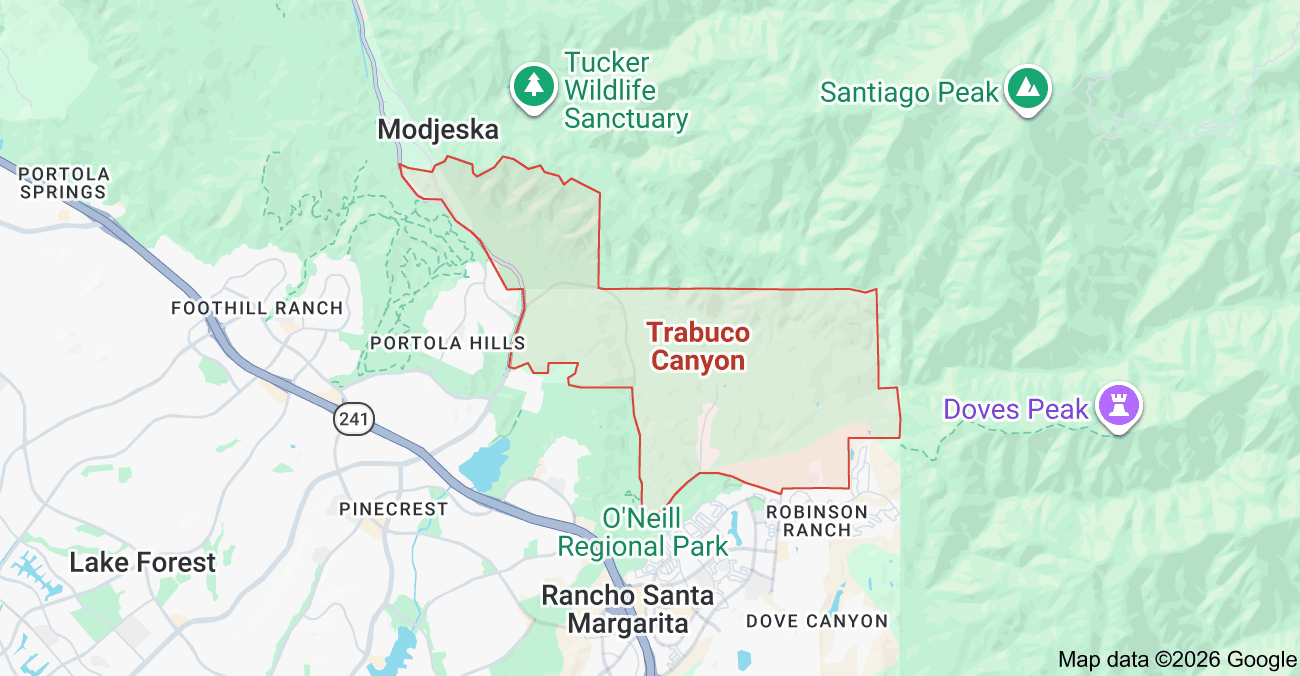
Orientation map showing Trabuco Canyon within South Orange County, California
Trabuco Canyon orientation map. For geographic orientation only. Do not rely on this image as an official municipal, market, subdivision, parcel or association boundary.

Open in Visual AtlasCompare This MarketClient Prep

Durable research last reviewed September 4, 2026

Market Brief

Trabuco Canyon in Brief

Market Identity

Trabuco Canyon is an unincorporated rural foothill market. What drives value here is land use rules, access, usable land, topography, infrastructure and property specific rights, not tract boundaries. The authentic canyon market is much smaller than the 92679 postal geography that shares its mailing address.

Housing Snapshot

There is no single production housing system. The durable structure runs from legacy canyon homes and Trabuco Oaks residential property through scattered custom acreage, equestrian oriented parcels and custom hillside homes, then into newer planned enclave housing at Saddle Crest and approved future development at Saddleback Meadows. Holy Jim sits apart as a federal recreation residence context and does not belong in ordinary detached home statistics.

Common Alternatives

  • Coto de Caza
  • San Juan Capistrano acreage and equestrian property
  • Nellie Gail Ranch
  • Silverado and Modjeska canyon property
  • Orange Park Acres
  • Rancho Santa Margarita foothill product
  • Portola Hills

Key Value Drivers

  • Usable land and property functionality
  • Access, privacy, road quality and legal ingress and egress
  • Topography, canyon or hillside position and the open space relationship
  • Water, wastewater and utility configuration
  • Permitted improvements and legal property configuration
  • Equestrian utility where it is legally supported
  • Current wildfire context and insurance feasibility

Important Watchouts

  • Foothill/Trabuco Specific Plan rules and County development constraints
  • Parcel specific access, easements, private roads, bridges and maintenance obligations
  • Water, sewer, septic, well and utility assumptions that were never verified
  • Fire hazard designation, emergency access and real insurance cost
  • Flood, drainage, creek, slope and retaining conditions
  • Permit and improvement history, including unpermitted structures
  • Taxes, address level school assignment and changing development status

Structured intelligence last reviewed September 4, 2026. School assignment, water and sewer service, septic or well configuration, road ownership, easement rights, fire hazard designation, insurance, taxes, assessments, horse keeping rights, development potential, permits, legal square footage, association obligations and current market statistics all have to be verified for the specific property.

Quick Intelligence

Trabuco Canyon Market Intelligence

A structured summary of the durable research below. The lens narrows this summary only. The full research sections on this page are always available.

Competitive Set

92679 is a postal geography, not a competitive set

Robinson Ranch, Dove Canyon, Trabuco Highlands, Coto de Caza and Portola Hills can all carry a Trabuco Canyon or 92679 mailing association while sitting in different jurisdictions and completely different housing markets.

  • Robinson Ranch, Dove Canyon and Trabuco Highlands are Rancho Santa Margarita
  • Portola Hills is Lake Forest
  • Coto de Caza is its own separate market
  • Confirm jurisdiction before you pull a single comp
Go deeper

The nearest sale may be the wrong comp

Seller

A custom acreage property, a Trabuco Oaks home, a newer Saddle Crest residence and a suburban 92679 tract home should not be blended just because they are close together.

  • Classify the property system first
  • Then compare land, access and infrastructure
  • Then compare improvements and carrying cost
Go deeper

Watchouts

The Specific Plan changes the property conversation

The Foothill/Trabuco Specific Plan carries district specific rules on density, open space, grading, landform and biological resources.

  • Acreage alone does not mean a parcel can be expanded, graded or subdivided
  • District rules differ across the plan area
  • Check the framework before you value a property around a future use
Go deeper

Utility configuration is part of the property

Do not read sewer, septic, public water, well or propane off the words Trabuco Canyon. Verify each system for the specific parcel.

  • Potable water provider and meter or private well
  • Sewer connection or onsite wastewater
  • Electric service and gas or propane arrangement
  • Private infrastructure serving the home
Go deeper

Fire designation and insurance are two separate questions

Buyer

Check current adopted fire hazard mapping for the address, then get real insurance quotes for the property.

  • Orange County unincorporated mapping carries more than one classification
  • A hazard designation is not an insurance decision
  • Do not carry one Trabuco Canyon insurance assumption across every property
Go deeper

Value Drivers

Usable land can matter more than recorded acreage

A smaller parcel with functional flat ground often solves a buyer problem better than a much larger parcel dominated by slope, drainage or difficult access.

  • Ask how much contiguous ground is flat or gently sloped
  • Ask whether a trailer can turn around
  • Ask where the drainage runs
  • Match usable area to the buyer objective
Go deeper

Why Choose It

Trabuco Oaks is a real internal market distinction

Buyer

Orange County formally identifies a Trabuco Oaks Residential district, TOR. That makes Trabuco Oaks more than an informal lifestyle label.

  • TOR is the district, not TCR
  • Analyze it separately from deep rural acreage and from suburban 92679 product
  • Community level research is still open
Go deeper

Tradeoffs

Access can be a value driver and a diligence issue at the same time

Buyer

Public paved access, private roads, shared maintenance, dead end spurs, bridges and creek crossings change convenience, financing, emergency access and buyer appeal.

  • Confirm legal ingress and egress through title
  • Identify public versus private road
  • Identify who maintains the access and who pays
  • Inspect the access physically
Go deeper

Agent Talking Points

Regulatory districts are overlays, not neighborhoods

Agent Study

TCR, TOR, UAR, ATR, BWR, PTR, PBR and the other Specific Plan districts matter enormously for land use. They are technical metadata, not consumer neighborhoods.

  • Store the district on the property record
  • Do not turn a planning district into a public community page
  • One property can carry several geographic attributes
Go deeper

Saddleback Meadows is future development, not an existing neighborhood

Agent Study

County records identify a 181 unit approved development framework in the Bridlewood Residential district.

  • Status stays dynamic and needs current County verification
  • Keep it out of existing resale inventory
  • Track it as development to watch
Go deeper

Key Questions

  1. 01

    Is this property actually in the Trabuco Canyon market, or does it just have a 92679 mailing address?

    Confirm jurisdiction, market identity and planning framework before you analyze a single comp. A Trabuco Canyon address can be Rancho Santa Margarita, Coto de Caza or Lake Forest.

    Go deeper
  2. 02

    Which Specific Plan district applies to this parcel?

    The rules are district specific. Trabuco Oaks, for example, is TOR rather than TCR, and that difference drives what can be done with the land.

    Go deeper
  3. 03

    How much of the recorded land is functionally usable?

    Look at flat pad, slope, drainage, access, protected land, easements and the real improvement area rather than the headline acreage.

    Go deeper
  4. 04

    How is the property reached, and who maintains the access?

    Public road, private road, shared access, dirt road, bridge, creek crossing and recorded maintenance obligations all change the answer.

    Go deeper
  5. 05

    What are the actual water and wastewater systems?

    Confirm public water, private well, sewer, septic and service boundaries for the parcel instead of assuming from the neighborhood name.

    Go deeper
  6. 06

    What does the current fire hazard map show, and can this buyer insure the property?

    Hazard designation and insurance availability are related but separate. Check the current adopted map for the address, then get real quotes early.

    Go deeper
  7. 07

    What improvements are legal, permitted and actually expandable under current County rules?

    Separate what already exists legally from what a buyer hopes to add. Both need County records, not assumptions.

    Go deeper
  8. 08

    What does this property truly compete against?

    Start with housing system, usable site, access, infrastructure and buyer intent, then widen the search. Distance is the last filter, not the first.

    Go deeper
  9. 09

    Is the open space relationship legally durable?

    Adjacency is not protection. Check what land actually adjoins the parcel, who owns it and what recorded status keeps it undeveloped.

    Go deeper
  10. 10

    Is the equestrian value based on verified rights and usable ground?

    Rural character is not a horse keeping right. Verify permitted use, structures, usable flat ground, water and trail access for the parcel itself.

    Go deeper

What this market actually is

Trabuco Canyon is unincorporated Orange County. There is no city hall, no municipal zoning code and no single master association. What organizes the market instead is County land use regulation, the shape of the land, how a property is reached, and how it is served with water, wastewater and power. Two neighbors here can own completely different property systems.

Unincorporated
Orange County is the local land use jurisdiction. There is no Trabuco Canyon city government.
Census designated place
The 2020 Census reported 1,020 residents, 372 housing units and roughly 7.28 square miles for the Trabuco Canyon CDP.
Foothill/Trabuco Specific Plan
Adopted by Orange County in 1991 and still the active planning framework for the canyon.
92679
A postal geography shared with Rancho Santa Margarita and Lake Forest communities. It is not the market.
Saddleback Valley Unified
The district framework for the canonical canyon market, with Trabuco Elementary on Trabuco Canyon Road. Assignment is verified by address.
Airport Fire, 2024
CAL FIRE incident reporting records roughly 23,526 acres burned, 160 structures destroyed and 34 damaged.

The 92679 trap

This is the first thing I check on any canyon property, before comps, before pricing, before anything. A Trabuco Canyon, CA 92679 mailing address does not mean the property is in the Trabuco Canyon market.

Rancho Santa Margarita

Incorporated city

Several major 92679 communities are inside the City of Rancho Santa Margarita.

  • Robinson Ranch
  • Dove Canyon
  • Trabuco Highlands
  • Rancho Cielo
  • Walden

Lake Forest

Incorporated city

Portola Hills is part of the City of Lake Forest and belongs under that City Market.

Coto de Caza

Separate market

Coto has its own market system and its own Orange County Specific Plan. It is never a Trabuco child area.

A useful illustration

Postal versus municipal

Trabuco Canyon Water District itself uses a Trabuco Canyon 92679 mailing address at a Dove Canyon location. Same ZIP, different city.

The permanent rule

Say it out loud

92679 is a postal geography, not a competitive set. Confirm jurisdiction before you compare anything.

The data rule

Before any statistics

A market snapshot built by querying ZIP 92679 would blend incorporated suburban tract housing into a rural canyon market. That is why no city statistics are published here yet.

Physical geography

Trabuco Canyon sits at the western foothills of the Santa Ana Mountains. In this market, geography is not scenery in the background of a photo. It is part of the property.

What shapes the canyon

The market is physically defined by drainage, terrain and the open space around it.

  • Arroyo Trabuco and Trabuco Creek
  • Live Oak Canyon and Rose Canyon
  • Rising foothill terrain
  • O'Neill Regional Park
  • Cleveland National Forest
  • A limited rural road network

What it changes about a home

Terrain here reaches into the ordinary parts of ownership.

  • Buildable area and road access
  • Sunlight, wind and drainage
  • Slope, views and usable land
  • Wildfire interface and emergency access
  • Privacy, noise and landscaping
  • Ongoing maintenance

How to use it

Walk the land, not just the house. Read the drainage, the access and the slope before you form a price opinion.

Map and planning geography

A conventional color coded tract map is not the right first visual for this market. The useful one is the County planning map, because land use districts explain more about a canyon property than subdivision lines do.

A future Trabuco Canyon market geography map is planned. It would show the CDP, the Specific Plan boundary and districts, Trabuco Oaks, the rural core, Live Oak and Rose Canyon, Saddle Crest, Saddleback Meadows, the park and forest, and the Rancho Santa Margarita, Lake Forest and Coto boundaries around them.

How to read a canyon property

Work in this order. Skipping a step is how agents end up pricing a rural parcel like a tract home.

  1. 01

    Jurisdiction

    Is this the canyon market, or a 92679 address inside another city?

  2. 02

    District

    Which Specific Plan district governs the parcel, and what does it allow?

  3. 03

    Land

    How much of the acreage is usable, and how does water move across it?

  4. 04

    Infrastructure

    Access, water, wastewater and power, confirmed for this parcel.

  5. 05

    Risk and cost

    Fire designation, real insurance quotes, taxes and maintenance.

Canonical hierarchy

Trabuco Canyon has no clean tract ladder the way a master planned community does. The honest structure is a short list of recognized places plus a set of technical overlays that never become public neighborhoods.

Public geography

Recognized places

These carry real market identity and are researched as areas under Trabuco Canyon.

  • Trabuco Oaks, a community inside the TOR district
  • Saddle Crest, a modern planned enclave
  • Saddleback Meadows, approved future development
  • Live Oak and Rose Canyon, a canyon analysis area with an unsettled boundary
  • The rural canyon core, held as an internal analysis segment

Technical overlays

Planning districts

TCR, TOR, UAR, ATR, BWR, PTR, PBR and the rest are land use metadata stored on the property record.

  • They govern density, grading and open space
  • They are not consumer neighborhoods
  • One property can carry several geographic attributes at once
  • A planning district does not earn a public page

Special context

Held apart

Holy Jim recreation residences sit under Trabuco Canyon for research discovery only.

  • Federal permit system rather than ordinary fee simple ownership
  • Excluded from standard detached home statistics
  • Current status needs U.S. Forest Service verification

None of the child records above has a standalone page yet. They are listed here because the names matter, not because the research is finished.

Foothill/Trabuco Specific Plan

Orange County adopted the Foothill/Trabuco Specific Plan in 1991, and it is still the active planning framework for the canyon. It is the single most important document behind what a parcel here can become.

What the County maintains

The plan is live, not historical.

  • Specific Plan planning materials
  • A formal land use district map
  • Development review processes
  • The Foothill/Trabuco Specific Plan Review Board

What it can control

District rules reach into most of what a buyer wants to change.

  • Residential density and subdivision design
  • Grading and landform alteration
  • Natural open space
  • Oak and biological resources
  • Scenic corridors and public facilities
  • Roads and circulation
  • Discretionary development review

The rule I hold to

I do not describe a canyon property as subdividable, easily expandable, suited to major grading, guaranteed for an accessory unit or ready for a large barn until the parcel has been checked against current County rules.

Open space standards

County materials tie a minimum 66 percent natural open space standard to certain project proposals in specific districts, including Upper Aliso Residential and Trabuco Canyon Residential, subject to the plan exclusions and conditions.

Portions of the plan impose unusually restrictive open space, grading and landform standards. The rules vary by district and by property, so development potential is evaluated against the parcel land use designation and current County requirements.

The Review Board

The Review Board is a County advisory body tied to development review in the plan area. It is not a city council, not an HOA and not the final County decision maker on every application. Its continued existence is evidence the framework is active.

Where to send a client

Development and major improvement questions go to current Orange County planning resources rather than to historic assumptions or neighbor stories.

Land use districts

The authoritative County map is more detailed than most secondary summaries suggest. These codes belong on the property record as technical metadata.

CodeDistrict
OSCOpen Space Conservation
ATRArroyo Trabuco Residential
BWRBridlewood Residential
PTRPlano Trabuco Residential
PBRPortola Bluff Residential
TCRTrabuco Canyon Residential
TORTrabuco Oaks Residential
UARUpper Aliso Residential
GWCGateway Commercial
TCCTrabuco Canyon Commercial
PQFPublic and Quasi-Public Facilities
RLLRancho Las Lomas
SGSand and Gravel Extraction overlay
FP-2Floodplain overlay

Correction carried permanently: Trabuco Oaks is its own district, TOR, not part of TCR.

Planning geography versus market geography

This is the permanent lesson Trabuco Canyon teaches better than any other South Orange County market. Regulatory geography and real estate geography are two different maps of the same ground.

Regulatory

What the County map is for

Zoning and land use, grading, open space standards, development review, environmental constraints and County approvals.

  • TCR
  • TOR
  • UAR
  • BWR
  • ATR

Real estate

What the market map is for

Buyer search, comp selection, community identity, showing preparation and listing positioning.

  • Trabuco Oaks
  • Saddle Crest
  • The rural canyon core
  • Live Oak and Rose Canyon

A property carries both. Neither one is allowed to overwrite the other in this database.

Trabuco Oaks

Trabuco Oaks is a legitimate community level distinction inside this market, and the evidence is stronger than a consumer label: Orange County identifies a formal Trabuco Oaks Residential district, TOR.

Why it stands on its own

Recognized as a district

County planning recognizes it as its own residential district, and it holds a recognizable residential geography distinct from surrounding TCR land.

  • It is TOR, not TCR
  • Property conditions can differ from suburban 92679 product
  • Analyze it separately from deep rural acreage
  • Tract and parcel research can go meaningfully deeper here

What is still open

Before a community page exists

I am not publishing a thin community page on the strength of a district name.

  • Exact canonical boundary
  • Recorded parcel and tract geography
  • Road maintenance structure
  • Water and wastewater configuration by parcel
  • Original development chronology
  • Verified housing counts and construction era pattern
  • Builder and custom home history
  • Association or road association status
  • MLS competitive set

Research priority: high.

Rural core, Live Oak and Rose Canyon

Two analysis areas that agents talk about constantly and that no map settles cleanly. I keep them as research objects rather than pretending the boundaries are known.

Internal segment

Trabuco Canyon rural core

The authentic rural canyon inventory: individually built homes, irregular sites, property specific infrastructure and no uniform product logic.

  • Held as an analysis segment, not a public place page
  • Used to keep suburban 92679 product out of canyon analysis
  • Needs recorded parcel research before it becomes anything more

Boundary unresolved

Live Oak and Rose Canyon

This geography can differ from the lower canyon in ways that matter to a buyer.

  • Access and road type
  • Topography and slope
  • Acreage and creek crossings
  • Wildfire interface and emergency egress
  • Utilities and equestrian usability

Exact boundary and product study remain open. A future custom geography map would make this area far easier to study.

Saddle Crest

Saddle Crest is a real planned residential enclave inside the broader foothill geography, and it behaves nothing like legacy canyon housing. It is also where a common published error lives.

Correction

Tract 17388

Secondary research circulated Tract 17351. Authoritative records identify Orange County Tract No. 17388. That correction is permanent here.

  • Recorded tract: 17388
  • Carried as a tract level record under Trabuco Canyon
  • Specific Plan context: Foothill/Trabuco

Research leads, not facts

What is not published yet

Secondary sources associate the enclave with later luxury housing, a national builder, gated access and association governance. Those are leads. They stay unpublished until a tract level pass confirms them.

  • Canonical marketing name
  • Builder and original sales program
  • Exact home count and years built
  • Plan names, square footage and lot ranges
  • Association structure and utility structure
  • Current gate operation

Saddleback Meadows

Saddleback Meadows is future development. It is not an existing neighborhood, and it does not belong in resale inventory or in comps.

Planning context

Bridlewood Residential district

Current Orange County planning records identify the project inside the BWR district, with a development framework for approximately 181 residential units and a long, complicated entitlement history.

  • District: BWR
  • Approximately 181 residential units in the County framework
  • Do not apply the TCR and UAR open space discussion here
  • BWR carries its own entitlement and planning history

What to monitor

Everything here is dynamic

This record is reviewed against current County status rather than treated as settled.

  • Project approvals and litigation
  • Grading and construction start
  • Builder, final plan and unit count
  • Roads, emergency access and utility infrastructure
  • Association structure and any special tax structure
  • Release dates

No completed home in this project is treated as existing resale inventory until homes exist.

Holy Jim and forest recreation residences

The Holy Jim cabin environment is a federal recreation residence system inside Cleveland National Forest. It is not ordinary fee simple residential real estate and it is never blended into canyon housing statistics.

Different ownership system

Special use permits with the U.S. Forest Service behave nothing like a recorded fee simple purchase.

Open questions

Anyone working here needs current answers, not historical ones.

  • Permit status and land ownership
  • Cabin ownership and transferability
  • Post fire rebuilding rights
  • Current closure orders and access
  • Utilities and insurability

What I will not publish

An old cabin count, or any assumption that historic permit rights survived unchanged after the 2024 Airport Fire.

Research priority: high

What is not Trabuco Canyon

Postal association and foothill scenery are not membership. These places are researched under their own markets, and I keep them there deliberately.

Rancho Santa Margarita

Incorporated city

Robinson Ranch, Dove Canyon, Trabuco Highlands, Rancho Cielo and Walden are Rancho Santa Margarita communities.

Portola Hills

Lake Forest

Part of the City of Lake Forest and researched under that City Market.

Coto de Caza

Standalone market

Its own market system and its own County Specific Plan.

Wagon Wheel

Separate research object

A distinct unincorporated community with its own eventual parent decision. Not a Trabuco child area.

Silverado and Modjeska

Different canyons

Separate canyon markets under a different County Specific Plan.

Rancho Mission Viejo

Standalone market

Its own City Market on this platform.

Development history

The canyon was never built by one program. It accumulated, and that is why the housing looks the way it does.

  1. Pre-European period

    Acjachemen and Juaneno presence in the watershed

    Cultural resource context that is sourced carefully rather than turned into modern property claims.

  2. Spanish exploration era

    The Trabuco place name enters the map

    The name is historically associated with the Spanish period and the term for a blunderbuss. It gives the place a durable identity.

  3. 19th century

    Rancho Trabuco and the larger ranch era

    Ranching ownership eventually connected with Forster and O Neill patterns across South Orange County, which explains broad landholding shapes.

  4. 1907 era

    Cleveland National Forest established

    Federal protection fixed a permanent eastern open space boundary and preserved the nonurban context of the canyon.

  5. Early and mid 20th century

    Cabins, custom homes and rural parcels

    Settlement came through recreation and individual building rather than a coordinated suburban builder program. That produced nonuniform housing and parcel patterns.

  6. Mid 20th century onward

    Trabuco Oaks and rural residential pockets

    Recognizable semi rural residential geography forms inside the canyon.

  7. Late 20th century

    Suburban growth arrives next door

    Rancho Santa Margarita, Dove Canyon, Coto de Caza and Portola development create the postal and market geography confusion agents still fight today.

  8. 1991

    Foothill/Trabuco Specific Plan adopted

    Orange County establishes the durable planning framework for the foothill and canyon area.

  9. 2000

    Rancho Santa Margarita incorporates

    Robinson Ranch, Dove Canyon, Trabuco Highlands and others become incorporated city communities while keeping 92679 mail.

  10. 2000s to present

    Property specific and enclave development

    Growth is parcel by parcel and project by project, which is why there is no single citywide builder narrative.

  11. 2024

    Airport Fire

    The major current hazard and recovery context for the market.

  12. 2020s

    Saddle Crest resale and Saddleback Meadows approvals

    A modern planned housing layer sits alongside the legacy canyon, with development research ongoing.

Exact dates, builders and project completion details are tied to authoritative records before they are published as facts.

Housing product

There is no dominant production housing system here. The durable way to organize the market is by product type, because each type asks different questions.

Legacy canyon housing

Type A

Individually built homes, varied construction eras, nonuniform plans, irregular sites, additions, mature canopy and property specific infrastructure.

  • Permit history and legal square footage
  • Foundation, roof, electrical and plumbing
  • Wastewater and access
  • Drainage and retaining walls
  • Wildfire hardening

Trabuco Oaks

Type B

A recognizable semi rural community inside the TOR district, analyzed separately from deep rural acreage, suburban Rancho Santa Margarita and modern enclaves.

Custom acreage and equestrian oriented property

Type C

Scattered rather than one tract. Value tends to follow usable flat acreage, trailer access, barn, turnout and arena potential, privacy and trail access.

All rights verified at the parcel.

Hillside custom property

Type D

Topography creates views and privacy on one side, and slope constraints, wind exposure, access challenges and retaining and drainage obligations on the other.

Modern planned enclave

Type E

Saddle Crest is the clearest current example and will eventually carry a conventional builder, plan and tract analysis.

Future planned development

Type F

Saddleback Meadows sits in development monitoring, not the resale inventory library.

Federal recreation residences

Type G

Holy Jim is a permit system and stays out of standard detached home analysis.

Construction era diligence

Age tells you which questions to ask. It does not tell you the answers, and I never publish blanket defect claims about canyon housing.

Older homes

What to ask

Questions, not conclusions.

  • Foundation type and unreinforced masonry
  • Electrical capacity and roof
  • Insulation and plumbing
  • Wastewater system age
  • Additions and accessory structures
  • Defensible space, windows and vents
  • Code upgrades

Mid century and later rural custom

What to ask

The same discipline applied to a different era.

  • Slab and foundation condition
  • Drainage and plumbing
  • Roofing and wastewater
  • Remodel permits
  • Barns, garages and retaining walls

Modern homes

What to ask

Newer construction shifts the questions toward compliance and cost.

  • Wildfire resistant construction standards where applicable
  • Fuel modification obligations
  • Solar and retaining systems
  • Association obligations in planned enclaves
  • Current insurance

The correct language is: this property uses an onsite wastewater system, so we need to understand the specific system, permits, condition and future replacement area.

Roads, access and easements

How a property is reached is part of what it is worth. Main canyon access includes Trabuco Canyon Road, Trabuco Creek Road, Live Oak Canyon Road, Santiago Canyon Road and Plano Trabuco Road, with regional connection toward the 241.

What varies

Access conditions

Two homes a mile apart can carry completely different access obligations.

  • Public versus private road ownership
  • Pavement, gravel or dirt
  • Private bridge or creek crossing
  • Dead end access and shared driveways
  • Ingress and egress easements
  • Maintenance agreements and shared costs
  • Emergency vehicle access
  • Storm washout and drainage
  • Wildfire evacuation

The process

Diligence on a nonstandard access property

I run this in order and do not skip the physical inspection.

  • Confirm legal ingress and egress through title
  • Identify public versus private road
  • Identify maintenance responsibility
  • Inspect the access physically
  • Identify bridge or crossing responsibility
  • Confirm lender requirements where private road issues matter
  • Evaluate current fire and emergency access

What not to say

No blanket claims

Not all canyon roads are private or unmaintained, and not every rural property has a single egress route. Easy paved access can improve buyer acceptance, but no fixed premium is assigned without MLS evidence.

Utilities and wastewater

This is where the biggest oversimplifications in canyon real estate live. Utility configuration is part of the property itself, and neighboring parcels can carry different infrastructure and different obligations.

Determine separately

Eight things, per parcel

None of these are assumed from the address.

  • Potable water provider
  • Public meter versus private well
  • Sewer connection versus onsite wastewater
  • Wastewater permits and condition where applicable
  • Electric service
  • Gas or propane arrangement
  • Internet and telecom where material
  • Private infrastructure serving the home

Onsite wastewater

Where a septic system is present

The diligence is specific and it drives what the property can support.

  • Tank location and system type
  • Permit and record history
  • Capacity and inspection
  • Pumping history
  • Leach and dispersal area
  • Replacement area
  • Bedroom count implications
  • Expansion plans
  • Groundwater and soil constraints

Before we talk about adding bedrooms or a guest unit, we need to understand the approved wastewater system and what the property can support.

Water

What to verify when water is material

Water reaches financing, expansion, landscaping, equestrian use, fire review and future improvements.

  • Provider and meter
  • Service line
  • Well presence, permit, production and quality where applicable
  • Fire flow requirements where development is contemplated

Trabuco Canyon Water District serves the canyon and portions of surrounding South Orange County, but a service boundary does not mean every parcel has identical service.

Lot usability

In this market usable land can matter more than headline acreage. Recorded acreage is a number on a page. Usable ground is what the buyer actually gets.

What acreage can hide

Recorded area often includes ground nobody can use.

  • Steep slopes and drainage
  • Creek corridor
  • Protected oak and habitat areas
  • Open space restrictions
  • Access and utility easements
  • Fuel modification areas
  • Unbuildable terrain

Better questions

These are the ones I walk the property asking.

  • How much contiguous ground is flat or gently sloped
  • Can a trailer turn around
  • Is there usable yard
  • Is there room for horses where legally permitted
  • Is there a functional secondary building area
  • What grading would be required, and is it allowed
  • Where are the drainage paths
  • Does the usable area match the buyer objective

Canyon bottom, hillside, ridge

Position within the canyon is an analysis framework, not a pricing rule. Each position trades something away.

Lower canyon

Canyon bottom

Tree canopy, rural atmosphere, flatter alluvial ground, creek character and wind protection in some spots.

  • Tradeoffs: drainage and flood context
  • Shade and dampness
  • Limited winter sun
  • Creek access issues

Elevated

Hillside

Views, sun, privacy and separation.

  • Tradeoffs: slope and retaining walls
  • Wind and wildfire exposure
  • Access
  • Usable yard limits

Upper foothill

Exposed ridge

Expansive views and openness.

  • Tradeoffs: high wind
  • Fire interface
  • Grading and ridgeline constraints
  • Road exposure

Always evaluate the actual property rather than the position category.

Flood, drainage and soils

Watershed geography makes drainage diligence more important here than in a conventional graded tract. It also makes lazy assumptions easy.

Water

Flood and drainage questions

Answered from mapping and site conditions, never inferred from the word canyon.

  • FEMA flood zone and floodplain overlay
  • Creek setback, culvert and bridge
  • Drainage easement and storm flow
  • Debris flow and erosion
  • Post fire watershed behavior
  • Slope drainage and retaining systems

Ground

Soils and slope questions

Property specific, and not published as a universal claim about canyon soils.

  • Slope stability and expansive soil
  • Foundation performance
  • Retaining walls and drainage
  • Grading permits
  • Geotechnical reports
  • Erosion and evidence of creep or landslide

This is a hillside and canyon property, so I want to understand the site and drainage reports rather than assume the house behaves like a flat suburban tract home.

Wildfire and insurance

Wildfire belongs near the center of diligence here, and it needs to be handled precisely rather than dramatically. Fire hazard designation is not the same thing as insurance availability.

2024

Airport Fire

The fire began in the Trabuco Canyon area in September 2024. CAL FIRE incident reporting records approximately 23,526 acres burned, 160 structures destroyed and 34 damaged. It is part of the durable recent history of this market.

  • Recovery context still shapes property condition questions
  • Post fire watershed behavior affects drainage diligence

Designation

Fire hazard severity zones

The adopted County framework for unincorporated areas includes more than one classification, so a blanket claim that every canyon property is in the highest zone is wrong.

  • Address, then current adopted map, then property specific diligence

Access

Fire access conditions

Fire authority review recognizes that canyon properties can carry special water and access concerns.

  • Road width and access
  • Dead end condition
  • Bridge or crossing
  • Hydrant and water supply
  • Fuel modification and defensible space
  • Vegetation and home hardening
  • Evacuation route

Cost

Insurance workflow

Insurance is dynamic and property specific, so no premium range or carrier assumption is published here as a market fact.

  • Identify the current fire hazard context
  • Gather property information
  • Obtain actual quotes
  • Compare admitted, nonadmitted and FAIR Plan structures where applicable
  • Review lender requirements
  • Put the real carrying cost into the buyer decision

Check insurance early, before the offer, not after.

Condition

Hardening diligence

Roof, vents, eaves, windows, siding, decks, vegetation, fuel modification, defensible space, access, water supply, sprinklers and backup systems where relevant. No home is described as fire safe, and code era is not a substitute for inspection.

Equestrian intelligence

The canyon has a genuine rural and equestrian identity. That identity does not give any particular property legal horse keeping rights, and the difference is where deals go wrong.

Separate these

Ten different things

They get collapsed into one word, horses, and they should not be.

  • Equestrian community identity
  • Nearby trails
  • Deeded trail easement
  • Legal animal keeping rights
  • Usable flat acreage
  • Barn and stable permits
  • Trailer access
  • Turnout and arena feasibility
  • Water and drainage
  • Neighborhood restrictions

For buyers

The question that sorts it out

Do you want to live near horses and trails, or do you actually need to keep horses on the property? Those are two different searches and two different price conversations.

For sellers

Document the capability

If equestrian use is a real selling feature, show it rather than assert it.

  • Legal structures and permits
  • Usable land
  • Trail and access rights
  • Trailer access
  • Water and fencing
  • Actual day to day functionality

Schools

The durable framework for the canonical canyon market is Saddleback Valley Unified School District, and Trabuco Elementary is an active district school on Trabuco Canyon Road.

The durable part

District framework and the presence of a canyon elementary school are stable facts that hold up over time.

The part that is not durable

Assignment is address specific and can change, so no permanent feeder chain is published here as a guarantee for every canyon property.

How to answer it correctly

Trabuco Canyon is within the Saddleback Valley Unified School District framework, and Trabuco Elementary is located in the canyon. Exact elementary, intermediate and high school assignment is verified by property address through the district school locator.

Governance

There is no city hall. What exists instead is a stack of separate authorities, and blurring them is one of the fastest ways to give a client wrong information.

Public

Who governs what

Each of these has a different role and a different process.

  • Orange County Board of Supervisors
  • OC Development Services
  • OC Public Works
  • Orange County Sheriff
  • Orange County Fire Authority
  • Special districts
  • School district
  • Federal land agencies where relevant

Private

Property specific obligations

Private governance in the canyon is often a document, not an office.

  • Association where one exists
  • Road maintenance agreement
  • Easements
  • Private gate
  • Shared infrastructure
  • Maintenance covenants

Advisory

Specific Plan Review Board

A County advisory body tied to development review in the plan area. It is not a city council, not an association and not the final County decision maker on every application.

Trabuco Canyon Water District

The water district is a public special district serving a territory broader than the Trabuco Canyon place boundary. It is infrastructure geography, not a neighborhood boundary.

What to confirm per property

Service is verified at the parcel rather than inferred from the postal city.

  • Water service
  • Wastewater service
  • Verified service connection
  • Fees and capacity if development is contemplated

Why it is easy to get wrong

The district itself uses a Trabuco Canyon 92679 mailing address at a Dove Canyon location. A mailing address proves nothing about jurisdiction or service.

Associations and private obligations

There is no single master association governing this market. That does not mean a legacy canyon property carries no private obligations.

Legacy property

Often no conventional association

Obligations still show up in recorded documents rather than in a monthly statement.

  • Road maintenance
  • Easements and shared access
  • Private infrastructure
  • Deed restrictions

Planned enclaves

Conventional structures exist

Saddle Crest and future planned development can carry ordinary association governance, and those obligations are dynamic.

No monthly dues figure is published here unless it comes from a current official association or disclosure source with a stated date.

Taxes and assessments

Taxes here are parcel specific. The right question is never what the Trabuco Canyon rate is, it is what is actually on this tax bill.

Workflow

How to answer a tax question

Five steps, in order, on every property.

  • Start from the parcel number
  • Pull the current secured tax bill
  • Read the special assessment line items
  • Check County Mello-Roos and community facilities district resources
  • Go to the issuing agency where necessary

Not published

Three claims I will not make

Generalized figures become permanent errors, so they stay out of this market record.

  • One Trabuco Canyon tax rate
  • No Mello-Roos as a blanket market claim
  • A seller current bill treated as a buyer future bill

Open space and recreation

Open space defines this market physically and financially. It also gets described carelessly more often than anything else in a canyon listing.

O Neill Regional Park

The defining anchor

A major regional open space system along Arroyo Trabuco and one of the defining geographic buffers around the canyon. County documents report acreage differently depending on the source and treatment of fee owned and easement land, so no single figure is published here.

  • Direct park boundary or not
  • Trail access
  • Weekend activity levels
  • Privacy and view protection
  • Wildfire interface
  • Recorded easements

Cleveland National Forest

The federal boundary

The forest creates a major federal open space edge and a recreation context, along with federal land management rules, trail closure orders, post fire restrictions and a separate permit system for recreation residences.

Current trail and forest access is checked through the U.S. Forest Service. Stale closure dates are not published as durable fact.

Verification

The rule about the land behind the house

Undeveloped land is never described as permanent open space until ownership or conservation status is verified.

  • OC Parks
  • U.S. Forest Service
  • Recorded conservation easement
  • Dedicated Specific Plan open space
  • Private undeveloped land that can change

Lifestyle and practical geography

The useful question is not whether the canyon is beautiful. It is whether a buyer actually wants the responsibilities that come with this property system.

What you get

The upside

Materially different from suburban South Orange County.

  • Rural setting and mature native landscape
  • Canyon roads and open space adjacency
  • Hiking, biking and equestrian access
  • Privacy and low density
  • Separation from conventional retail centers

What comes with it

The tradeoffs

None of these are dealbreakers. All of them are real.

  • Longer drive for daily services
  • Rural road conditions
  • Utility differences
  • Fire and emergency access diligence
  • Property maintenance
  • Wildlife
  • No sidewalks or streetlights in some areas
  • Variable internet and telecom where material

Buyer fit and diligence

A buyer who likes the idea of rural living may not like the actual road, insurance, wastewater system, maintenance or commute. My job is to test that match early, not after the inspection period opens.

Good fit

Buyers who do well here

They are buying a property system, not just a house.

  • Privacy, acreage and usable land
  • Horses and equestrian utility
  • Open space and mature trees
  • Custom housing and rural atmosphere
  • Reduced association control on some properties
  • Distance from dense suburban development

Poor fit

Nonnegotiables that do not survive the canyon

If these are requirements, another market serves the buyer better.

  • Predictable uniform utilities
  • Sidewalks and short walks to retail
  • Association maintained exterior systems
  • Highly standardized housing
  • Minimal property maintenance
  • No wildfire or rural access diligence

Diligence

What a serious buyer investigates

More than a conventional tract buyer, in nine areas.

  • Geography and jurisdiction, including district and parcel map
  • Access, easements, maintenance agreements and crossings
  • Land usability, slope, drainage, flood and open space restrictions
  • Utilities including water, wastewater, electric and propane
  • Fire hazard context, access, hardening and actual insurance quotes
  • Improvements, permits and legal square footage
  • Equestrian rights, structures and trailer access
  • Carrying costs including taxes, assessments and maintenance
  • Address level school verification

Seller intelligence

Selling here is a documentation exercise. The seller who reduces buyer uncertainty before launch keeps control of the price conversation.

Before pricing

Know what system you are selling

Identify the property type honestly before a number is discussed.

  • Rural core, Trabuco Oaks or planned enclave
  • Usable lot and access
  • Water and wastewater configuration
  • Improvements and permit history
  • Equestrian utility
  • Open space relationship
  • Fire and insurance context

Pricing

Where price per square foot breaks down

This metric is unusually weak in the canyon.

  • Land utility differs between comparables
  • Infrastructure differs
  • Access differs
  • One home has legal equestrian improvements and another has an unusable slope
  • One home is documented and another has substantial unpermitted work

Preparation

The pre listing property file

Assemble what a careful buyer will ask for, and let it work for you.

  • Permit history and building records
  • Wastewater and well or water information
  • Road, easement and maintenance documents
  • Survey or parcel map and tax bill
  • Association documents where applicable
  • Fire hardening upgrades
  • Roof, systems and drainage improvements
  • Barn and equestrian permits
  • Solar or generator information

The objective is to document, not to oversell. False certainty costs more than an honest unknown.

Comp selection

The closest sale is not automatically the best comp. In this market it usually is not. Classify the property first, then widen.

  1. 01

    Market membership

    Is the subject actually Trabuco Canyon, or only 92679?

  2. 02

    Property system

    Legacy rural, Trabuco Oaks, acreage and equestrian, hillside custom, planned enclave, or another verified system.

  3. 03

    Land

    Usable area, slope, privacy, creek, open space, yard and equestrian function.

  4. 04

    Infrastructure

    Access, road type, water, wastewater and utilities.

  5. 05

    Improvement quality

    Legal size, condition, remodel work, permits, systems and accessory structures.

  6. 06

    Risk and carrying cost

    Insurance, taxes and assessments, association and maintenance obligations.

  7. 07

    External alternatives

    Only now ask what other market this buyer could purchase instead.

Competitive sets

There is no single competitive set for this market. The buyer objective decides which comparison is honest.

Raw canyon character

Alternatives include Silverado Canyon, Modjeska Canyon and other unincorporated canyon property.

Tradeoffs: road and access, lot usability, remoteness, fire and infrastructure.

Equestrian acreage

Alternatives include Coto de Caza estate and equestrian product, San Juan Capistrano acreage, Nellie Gail Ranch and Orange Park Acres.

Tradeoffs: gates, association control, usable land, city services, access, price, fire and commute.

Foothill scenery without rural infrastructure

Alternatives include Robinson Ranch, Rancho Santa Margarita, Portola Hills and Coto de Caza.

Tradeoff: suburban predictability against rural privacy and acreage.

Newer luxury foothill housing

Alternatives include Coto de Caza, select Rancho Santa Margarita and Dove Canyon product, select modern foothill estate communities, and Saddle Crest itself.

Micro location framework

The competitive advantage in this market is property level analysis. These are the variables that actually move value between two homes on the same road.

Getting there

Access and topography

Two of the strongest differentiators in the canyon.

  • Public paved, private paved, dirt or gravel
  • Shared driveway, bridge or dead end spur
  • Road maintenance responsibility
  • Canyon bottom, hillside, bench or exposed ridge
  • Slope

The parcel

Land, water and open space

What the ground can do, and what moves across it.

  • Usable flat pad against gross acreage
  • Yard, barn and arena area, trailer access
  • Creek, drainage, floodplain, culvert and erosion
  • Adjacency to parks, forest, conservation easement, plan open space or private undeveloped land

Risk and daily life

Fire, privacy and usability

The variables that decide whether a buyer stays happy after year one.

  • Vegetation, access, current hazard mapping, fuel modification and insurance
  • Road exposure, neighboring improvements, public trail and recreation traffic
  • Permitted structures, outbuildings, retaining walls and grading
  • Drive time to services and employment, delivery access, school route and emergency access

Market data and MLS geography

Trabuco Canyon market statistics use CRMLS listings identified with the MLS city of Trabuco Canyon. MLS search geography may not match legal, postal, Census, or planning boundaries exactly.

The definition

What the search geography is

Statistics on this page come from CRMLS records whose MLS city is Trabuco Canyon. That is a listing-input geography maintained by agents, not a legal or planning boundary.

  • MLS city equals Trabuco Canyon
  • No ZIP, subdivision or polygon filter
  • No manual inclusions or exclusions

The problem it avoids

Why ZIP 92679 is not used

Searching by postal geography or ZIP 92679 pulls in housing from other jurisdictions and quietly rewrites the numbers.

  • Rancho Santa Margarita
  • Coto de Caza
  • Lake Forest
  • Other noncanonical foothill areas

Read them separately

How the statistics differ from the editorial geography

The canonical geography described elsewhere on this page is unchanged. Where an MLS record carries a Trabuco Canyon city value, it is counted, even when the property sits in a place this site treats as a separate market.

  • Editorial geography stays as written
  • Statistical geography is MLS-defined
  • Neither one overrides the other

Hypotheses

What I expect the data to show

These are hypotheses to test against the multiple listing service and repeat transactions, not published facts.

  • Usable flat land explains value better than gross acreage
  • Easy paved access improves liquidity against difficult private access
  • Public water and sewer widens the buyer pool, all else equal
  • Documented permitted improvements outperform uncertain additions
  • Durable open space adjacency earns a premium where fire and access tradeoffs stay acceptable
  • Fire insurance cost changes affordability and buyer pool
  • Saddle Crest behaves as a different competitive set from legacy canyon property
  • Suburban 92679 sales distort canyon statistics when included

Market Activity Index

Snapshot calculated September 8, 2026 at 6:10 AM Pacific (about 3 hours ago). These figures are generated on a schedule, not queried live when the page loads. The MLS feed itself last updated September 8, 2026 at 6:35 AM Pacific.

Market now

Point-in-time inventory at the calculation time above

Active listings

20

Status: Active only

Coming soon

1

Status: ComingSoon

Active under contract

8

Accepting backup offers

Pending

3

Under contract

Median active list price

$1.39M

Sample: 20 active listings

Median active days on market

38 days

MLS days on market, active inventory

Last 30 days

August 9 – September 8, 2026 · closed sales counted by close date

New listings

6

First listed in this window, whatever their status today. 40% fewer than the prior 30 days (10)

Closed sales

5

44% fewer than the prior 30 days (9)

Median closed price

$1.5M

17% higher than the prior 30 days ($1.28M)

Median closed days on market

95 days

280% longer than the prior 30 days (25 days)

Closed price per sq ft

$585/sq ft

Median of closed price divided by living area

Median Sale-to-Last-List

98%

Median closed price against the final list price. Against the original list price: 94%.

Price & sales trend

Complete calendar months only, September 2025 to August 2026. 114 closed sales in this window.

Trabuco Canyon closed sales, monthly count
Trabuco Canyon 3-month rolling median closed price(median of all closed sales in the trailing three months, not an average of monthly medians)

The 3-month rolling median closed price through August 2026 is 20% above the same rolling period a year earlier ($1.14M through August 2025), pooling 23 and 33 closed sales respectively.

Market balance

2.6 Months of Inventory

Seller-Leaning Market

Market Activity Index: current available inventory measured against the recent pace of closed sales, expressed as months of inventory.

Activity Index lookback

Current active listings

20

Point-in-time, status Active only

Avg closed / month

7.7

3 complete months · Jun 26 – Aug 26

Months of inventory

2.6

Seller's Market range

20 active listings ÷ 7.7 average monthly closed sales = 2.6 months of inventory. Current inventory is equal to approximately 2.6 months of sales at the recent 3-month closing pace, which falls in the Seller's Market range.

Trabuco Canyon monthly closed sales(historical). The horizontal lines mark the 3-month average closing pace and current Active inventory at the latest snapshot, a current count, not a past month.

Filled bars are the months inside the selected lookback. Lighter bars are earlier months shown for context. No month-by-month history of Active inventory has been stored yet, so none is drawn. Past Active inventory is never reconstructed from current listing statuses.

Months of inventory

Under 3 months · 3 to 6 months · over 6 months

2.6 mo
Seller’s Marketunder 3.0Neutral Market3.0 – 6.0Buyer’s Marketover 6.0

For orientation, this platform describes under 3.0 months of inventory as a Seller’s Market, 3.0 to 6.0 months as Neutral and over 6.0 months as a Buyer’s Market. These are market-balance ranges used by this platform; they describe the relationship between current supply and recent sales pace, and are not a recommendation to buy or sell.

Current competition by price band

Active listings only. 20 listings distributed across configured bands. Bar length is relative to the largest band.

  • Under $600K4 · 20%
  • $600K–$750K0 · 0%
  • $750K–$900K0 · 0%
  • $900K–$1.1M1 · 5%
  • $1.1M–$1.5M8 · 40%
  • $1.5M+7 · 35%
How these numbers are calculated

Source: CRMLS data via SimplyRETS. Market metrics are calculated from listings returned by the configured geographic query. Figures may change as MLS records are updated. Property-specific facts should be independently verified.

Geographic and property query: city in [Trabuco Canyon] AND types included [Residential, Condominium, Townhome]; excluded [Rental, Commercial, CommercialLease, Land, Farm, Multi-Family]. Methodology version v2.

  • Only residential for-sale property is counted. Rentals, commercial, land, farm and multi-family income records returned by the same geographic query are excluded before any figure is calculated.
  • Most recent retrieval: 37 records returned, 5 excluded as outside the residential for-sale universe, 0 excluded as outside the mapped area, 32 counted.
  • Active Listings: MLS status Active. Homes actively on the market. Excludes homes under contract, pending, or coming soon.
  • Coming Soon: MLS status ComingSoon. Listings publicly announced but not yet showing as active in the MLS.
  • Active Under Contract: MLS status ActiveUnderContract. Under contract while still accepting backup offers.
  • Pending: MLS status Pending. Under contract, no longer accepting offers through the MLS.
  • Closed Sales: MLS status Closed. Recorded closed transactions, grouped by close date.
  • New listings count homes first listed inside the window, whatever status they hold now, so a home that listed and went pending in the same window is still counted as new.
  • Monthly history uses complete calendar months only. The month in progress is never charted, because a partial month reads as a collapse in sales.
  • Medians and ratios are suppressed below 5 qualifying observations rather than published from a small sample.
  • Sale-to-last-list divides close price by the final list price. Sale-to-original-list uses the original list price where the feed populates it. Both are shown to the nearest whole percent, which is the honest resolution for a median over this many sales.
  • Price per square foot divides close price by MLS living area; listings without living area are excluded.
  • Months of inventory: current Active listings divided by average monthly closed sales, using the trailing 3 complete calendar months by default, with 6- and 12-month lookbacks offered only where that many complete, consecutive calendar months are stored. For orientation, this platform describes under 3.0 months of inventory as a Seller’s Market, 3.0 to 6.0 months as Neutral and over 6.0 months as a Buyer’s Market; these are market-balance ranges used by this platform, not a universal standard. It is also discussed elsewhere as months of supply or absorption; the figure shown here is months of inventory. Every calendar month in the window counts in the denominator, including verified zero-sale months. Both sides of the division come from the same residential-for-sale universe as every other number in this section, and the figure is withheld rather than published when a required calendar month is missing, the closed sample in the lookback is below the suppression threshold or the closing pace is zero.
  • The Market Activity Index chart draws historical monthly closed sales and current Active inventory at the latest snapshot as separate facts. No month-by-month history of Active inventory has been stored for this market yet, so none is drawn: past inventory levels are never reconstructed from current listing statuses.
  • Price charts use a 3-month rolling median of the pooled closed transactions, and the year-over-year figure quotes that same rolling median. Closed counts are monthly and unsmoothed.
  • Property tax figures are never derived from the MLS feed; the field is unpopulated in this feed. School, HOA and assessment facts come from the durable research on this page, not from listing data.
  • Snapshots are generated on a schedule rather than on page load, so figures reflect the calculation time shown above rather than a live query.
  • Listing change tracking began September 8, 2026. Price-reduction metrics appear only once a full tracking window exists.

Research priorities

This market rewards field work. Here is the queue, in order, and what each pass has to produce before anything is published.

Priority 1

Trabuco Oaks community profile

Exact boundary, district context, recorded parcels and tracts, access, utility configuration, housing counts, construction eras, property patterns, market behavior and micro location.

Priority 2

Saddle Crest tract profile

Tract 17388, builder, marketing name, home count, floor plans, square footage, lots, association, gate, taxes and assessments, utilities, fire and fuel modification, and resale performance.

Priority 3

Rural core geography pass

Exact public market boundary, Trabuco Creek Road pockets, parcel patterns, public and private roads, wastewater and water, housing typology and open space.

Priority 4

Live Oak and Rose Canyon pass

Canonical boundary, access, parcel pattern, planning districts, utilities, road and bridge issues, equestrian product, fire and open space context.

Priority 5

Holy Jim current status

Surviving recreation residences, current permits, rebuild policy, closures, transferability, insurance and current access.

Priority 6

Saddleback Meadows development watch

Litigation, project status, grading, builder, final product, association, taxes and infrastructure.

Field study

The drive that teaches this market

Trabuco Canyon Road, Trabuco Creek Road, the Trabuco Oaks area, Live Oak Canyon Road, Rose Canyon access where lawful, the Santiago Canyon context, park boundaries, Saddle Crest access, the Saddleback Meadows site and the transitions into Rancho Santa Margarita. Record road surface, shoulders, traffic, gates, crossings, elevation, slope, canopy, open space, trailhead activity, visible utilities, property type, lot usability and vegetation.

Respect private roads, gates, access restrictions and property rights.

Durable and dynamic knowledge

Some things about this market stay true for years. Others change quarter to quarter and need a date attached every time they are said out loud.

Durable

Structural knowledge

Learn these once and they keep paying.

  • Unincorporated Orange County status and Census place identity
  • The separation between 92679 and legal or market geography
  • The Specific Plan and its district framework
  • Trabuco Oaks as its own TOR district
  • County governance structure
  • Broad canyon geography and major roads
  • The park and national forest relationship
  • Saddle Crest as Tract 17388
  • Rancho Santa Margarita, Portola Hills, Coto and the other canyon exclusions
  • Broad housing product categories and the property level diligence framework

Dynamic

Verify every time

These are checked against a current source, with an as of date, for the specific property.

  • School assignment
  • Association dues and road maintenance charges
  • Utility service and fees
  • Wastewater and well condition
  • Fire hazard designation
  • Insurance availability and premium
  • Tax and assessment amounts
  • Saddleback Meadows status
  • Forest closures
  • Inventory, pricing and days on market
  • Builder sales status and current property condition

Open research

What is not finished here, stated plainly. None of it is filled in with an assumption in the meantime.

High priority

Seven open items

These block city level statistics and deeper child pages.

  • A parcel level boundary that cleanly separates the authentic canyon from Rancho Santa Margarita, Coto, Lake Forest and other unincorporated areas
  • A tested listing search geography that avoids the 92679 trap
  • Recorded geography and a product profile for Trabuco Oaks
  • A complete builder, floor plan, association and tract profile for Saddle Crest
  • Parcel level understanding of water district service, sewer, onsite wastewater and private wells
  • A better map of public and private road segments
  • A current property level fire and insurance workflow that does not turn dynamic conditions into durable claims

Medium priority

Five open items

Important, and next in line after the high priority queue.

  • Exact boundary and product study for Live Oak and Rose Canyon
  • Current post fire forest status for Holy Jim
  • Recorded parcel and tract history for legacy canyon pockets
  • Parcel, zoning and deed based verification examples for equestrian rights
  • Authoritative archival sources for exact Trabuco Oaks and canyon subdivision dates

Low priority

Two open items

Deliberately deferred.

  • A floor plan library outside Saddle Crest, since most legacy canyon product is custom
  • Tourism and restaurant content, unless it materially affects client logistics

Corrections log

This market is unusually full of confident secondary information that does not survive checking. Every correction below is permanent here.

Common claimWhat this record holds
Trabuco Canyon is unincorporatedConfirmed
It functions as a standalone marketSupported as a market taxonomy decision, not a claim of incorporation
2020 place population 1,020 and 372 housing unitsConfirmed
Specific Plan adopted in 1991Confirmed
The plan covers roughly 6,500 acresSupported
The plan has only a few residential districtsCorrected. The official map is substantially more detailed
Trabuco Oaks sits in the TCR districtCorrected to TOR
A 66 percent open space rule applies throughout the canyonNarrowed to specific districts and project proposals
All authentic canyon homes use septicRemoved as a blanket claim
Rural canyon homes generally use wells and propaneProperty specific
The entire canyon is in the highest fire hazard zoneNot published as a blanket claim
Most purchases require the FAIR PlanRemoved
Typical insurance runs 6,000 to 18,000 dollarsRemoved
The rural core has one general tax rateRemoved
Rural Trabuco has no Mello-RoosRemoved as a blanket claim
A fixed school feeder chain appliesRemoved. Verify by address
O Neill Regional Park is 4,500 plus acresReplaced with sourced, careful wording
Saddle Crest is Tract 17351Corrected to Tract 17388
Saddle Crest builder and plan details are settledNeeds tract level verification
Saddleback Meadows is a normal TCR style projectCorrected. It sits in BWR with its own entitlement history
Saddleback Meadows is an existing neighborhoodNo. Future planned development
Holy Jim is ordinary residential inventoryNo. Federal recreation residence context
Robinson Ranch belongs to Trabuco because of 92679False. Rancho Santa Margarita
Dove Canyon belongs to Trabuco because of 92679False. Rancho Santa Margarita
Trabuco Highlands belongs to TrabucoFalse. Rancho Santa Margarita
Portola Hills belongs to TrabucoFalse. Lake Forest
Coto de Caza belongs to TrabucoFalse. Separate market
Wagon Wheel belongs to TrabucoFalse. Separate unincorporated research object

Within this market

Communities & Tracts

  • Trabuco OaksCommunityResearch In Progress
  • Live Oak / Rose CanyonCommunityResearch In Progress
  • Saddle CrestTractResearch In Progress
  • Saddleback MeadowsTractResearch In Progress

Individual claims and classification

Market Knowledge Record

Legal geography

  • Trabuco Canyon is an unincorporated Orange County community and a Census designated place. There is no Trabuco Canyon city government, city council, municipal planning department or municipal zoning code.

    Verified Fact

  • Orange County is the primary local land use jurisdiction for the unincorporated Trabuco Canyon market.

    Verified Fact

Census

  • The 2020 Census reported a population of 1,020, 372 housing units and approximately 7.28 square miles of land area for the Trabuco Canyon Census designated place.

    Verified Fact

Market geography

  • ZIP 92679 is a postal geography rather than a market. Robinson Ranch, Dove Canyon, Trabuco Highlands, Rancho Cielo and Walden are communities of the City of Rancho Santa Margarita, and Portola Hills is part of the City of Lake Forest.

    Verified Fact

Planning

  • Orange County adopted the Foothill/Trabuco Specific Plan in 1991, and the County continues to maintain plan materials, a land use district map, development review processes and the Specific Plan Review Board.

    Verified Fact

  • Trabuco Oaks is its own Specific Plan land use district, Trabuco Oaks Residential, TOR. It is not part of the Trabuco Canyon Residential district.

    Verified Fact

  • County materials tie a minimum 66 percent natural open space standard to certain project proposals in specific districts, including Upper Aliso Residential and Trabuco Canyon Residential, subject to the plan exclusions and conditions. It is not a blanket canyon wide rule.

    Verified Fact

Tracts

  • Saddle Crest is recorded as Orange County Tract No. 17388.

    Verified Fact

Development

  • Saddleback Meadows sits within the Bridlewood Residential district, with a County development framework for approximately 181 residential units and a long entitlement history. It is future development rather than existing resale inventory.

    Verified Fact · as of September 4, 2026

Wildfire

  • The Airport Fire began in the Trabuco Canyon area in September 2024. CAL FIRE incident reporting records approximately 23,526 acres burned, 160 structures destroyed and 34 structures damaged.

    Verified Fact

  • The adopted Orange County fire hazard framework for unincorporated areas includes more than one classification, so fire hazard designation is verified by address against the current adopted map.

    Verified Fact · as of September 4, 2026

Schools

  • Trabuco Canyon sits within the Saddleback Valley Unified School District framework, and Trabuco Elementary is an active district school on Trabuco Canyon Road. Exact elementary, intermediate and high school assignment is verified by address through the current district school locator.

    Verified Fact · as of September 4, 2026

Utilities

  • Trabuco Canyon Water District is a public special district providing water and wastewater service across a territory broader than the Trabuco Canyon place boundary. District service is confirmed at the parcel rather than inferred from the postal city.

    Verified Fact

  • Canyon properties do not share a uniform utility configuration. Water provider, meter or well, sewer or onsite wastewater, electric service and gas or propane arrangements are determined property by property.

    Verified Fact

Taxes

  • Property taxes and special assessments in this market are parcel specific. No single Trabuco Canyon tax rate is published, and no blanket claim is made about the presence or absence of Mello-Roos special taxes.

    Verified Fact

Governance

  • There is no single master association governing the Trabuco Canyon market. Legacy properties may carry road maintenance, easement, shared access, private infrastructure or deed restriction obligations without a conventional association.

    Verified Fact

Open space

  • O Neill Regional Park is a major regional open space system along Arroyo Trabuco and one of the defining geographic buffers around the canyon. County documents report acreage differently depending on the source, so no single figure is published here.

    Verified Fact

  • Cleveland National Forest forms the major federal open space boundary east of the canyon and introduces federal land management rules, closure orders and a separate permit system for recreation residences.

    Verified Fact

Special areas

  • Holy Jim recreation residences operate under a federal special use permit system rather than ordinary fee simple ownership, and are excluded from standard detached home statistics for this market.

    Needs Verification · as of September 4, 2026

Market data

  • No city level pricing or inventory statistics are published for Trabuco Canyon because a canonical listing search geography that excludes Rancho Santa Margarita, Coto de Caza and Lake Forest product has not been validated yet.

    Verified Fact · as of September 4, 2026

Insurance

  • Insurance availability and premium in this market are dynamic and property specific. Fire hazard designation is not the same as insurance availability, and no premium range is published as a market fact.

    Verified Fact · as of September 4, 2026

Sources & Verification

Durable review
September 4, 2026
Dynamic data
September 8, 2026
Research status
City Intelligence Published